Sutter Avenue–Rutland Road (IRT New Lots Line)
Sutter Avenue–Rutland Road | |||||||||||||||||
|---|---|---|---|---|---|---|---|---|---|---|---|---|---|---|---|---|---|
|
| |||||||||||||||||
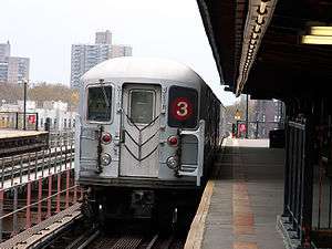 An R62 | |||||||||||||||||
| Station statistics | |||||||||||||||||
| Address |
Sutter Avenue / Rutland Road & East 98th Street Brooklyn, NY 11212 | ||||||||||||||||
| Borough | Brooklyn | ||||||||||||||||
| Locale | Brownsville | ||||||||||||||||
| Coordinates | 40°39′54″N 73°55′22″W / 40.664884°N 73.922882°WCoordinates: 40°39′54″N 73°55′22″W / 40.664884°N 73.922882°W | ||||||||||||||||
| Division | A (IRT) | ||||||||||||||||
| Line | IRT New Lots Line | ||||||||||||||||
| Services |
2 3 4 5 | ||||||||||||||||
| Transit connections |
| ||||||||||||||||
| Structure | Elevated | ||||||||||||||||
| Platforms | 2 side platforms | ||||||||||||||||
| Tracks | 2 | ||||||||||||||||
| Other information | |||||||||||||||||
| Opened | November 22, 1920 | ||||||||||||||||
| Rebuilt | October 5, 2016 to June 19, 2017 | ||||||||||||||||
| Station code | 346[1] | ||||||||||||||||
| Traffic | |||||||||||||||||
| Passengers (2017) |
1,049,559[2] | ||||||||||||||||
| Rank | 351 out of 425 | ||||||||||||||||
| Station succession | |||||||||||||||||
| Next north |
Crown Heights–Utica Avenue: 2 | ||||||||||||||||
| Next south |
Saratoga Avenue: 2 | ||||||||||||||||
| |||||||||||||||||
| |||||||||||||||||
| |||||||||||||||||


Sutter Avenue–Rutland Road is a station on the IRT New Lots Line of the New York City Subway, located at the intersection of Sutter Avenue, Rutland Road, and East 98th Street in Brownsville, Brooklyn. It is served by the 3 train at all times except late nights, when the 4 train takes over service. Occasional rush hour 2, 4 and 5 trains also stop here.[3][4][5][6]
Station layout
| P Platform level |
Side platform, doors will open on the right | |
| Northbound | ← ← | |
| Center trackway | No track or roadbed | |
| Southbound | | |
| Side platform, doors will open on the right | ||
| M | Mezzanine | Fare control, station agent, MetroCard machines |
| G | Street level | Exit/entrance |
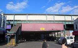
This elevated station, opened on November 22, 1920,[9] has two side platforms and two tracks with space for a center track that was never added. The middle third of both platforms have beige windscreens and brown canopies supported by green frames and support columns. The remaining two-thirds have red, waist-high steel fences with lampposts at regular intervals. The station signs are in the standard black name plates in white lettering.
This is the northernmost station on the IRT New Lots Line. To the north, the line curves west under Eastern Parkway and goes underground to become the IRT Eastern Parkway Line. The Manhattan-bound track goes underneath the New Lots Avenue-bound track on the south side of the IRT Eastern Parkway Line. A center track begins at a bumper block near the tunnel portal and merges with the two express tracks of the Eastern Parkway line south of Utica Avenue.
From October 5, 2016 to June 19, 2017, this station was closed for renovations.[10][11][12]
Exits
This station has one elevated station house beneath the platforms and tracks. Two staircases from the center of each platform go down to a waiting area/crossunder, where a turnstile bank provides access to/from the station. Outside fare control, there is a token booth and two staircases facing in opposite directions going down to the east side of East 98th Street at the T-intersection of Rutland Road. The north staircase is near the southern corner of the T-intersection of Sutter Avenue and East 98th Street. A third staircase goes down to the northwest corner of East 98th Street and Rutland Road.[13]
References
- ↑ "Station Developers' Information". Metropolitan Transportation Authority. Retrieved June 13, 2017.
- ↑ "Facts and Figures: Annual Subway Ridership 2012–2017". Metropolitan Transportation Authority. July 12, 2018. Retrieved July 12, 2018.
- ↑ "2 Subway Timetable, Effective June 24, 2018" (PDF). Metropolitan Transportation Authority. Retrieved June 24, 2018.
- ↑ "3 Subway Timetable, Effective June 24, 2018" (PDF). Metropolitan Transportation Authority. Retrieved June 24, 2018.
- ↑ "4 Subway Timetable, Effective June 24, 2018" (PDF). Metropolitan Transportation Authority. Retrieved June 24, 2018.
- ↑ "5 Subway Timetable, Effective June 24, 2018" (PDF). Metropolitan Transportation Authority. Retrieved June 24, 2018.
- ↑ Occasional 2 trains to Wakefield–241st Street and 5 trains to Nereid Avenue and Dyre Avenue also serve the station during rush hours.
- ↑ Occasional PM rush hour 2 trains to Wakefield–241st Street, one AM rush hour 4 train to Woodlawn, and one AM rush hour 5 trains to both East 180th Street and Dyre Avenue.
- ↑ "Annual report. 1920-1921". HathiTrust. Interborough Rapid Transit. Retrieved 2016-09-05.
- ↑ The Stations Were Closed for Renewal Work Since April, MTA, September 16, 2016.
- ↑ "ServiceAlert: As of 5 AM, the Sutter Av-Rutland Rd and Junius St stations have reopened for 3 and 4 subway service". @NYCTSubway. June 19, 2017. Retrieved June 19, 2017.
- ↑ "MTA | news | Sutter Av-Rutland Rd, Junius St Stations on 3 Line Reopen". www.mta.info. Metropolitan Transportation Authority. June 19, 2017. Retrieved June 19, 2017.
- ↑ "MTA Neighborhood Maps: Brownsville" (PDF). mta.info. Metropolitan Transportation Authority. 2015. Retrieved 19 July 2015.
External links

- nycsubway.org – Brooklyn IRT: Sutter Avenue/Rutland Road
- Station Reporter — 3 Train
- The Subway Nut — Sutter Avenue–Rutland Road Pictures
- Sutter Avenue entrance from Google Maps Street View
- Rutland Road entrance from Google Maps Street View
- Platforms from Google Maps Street View
| |
| |
| New Lots Line | |
|---|---|
| |