Sussex Parish, New Brunswick
| Sussex | |
|---|---|
| Parish | |
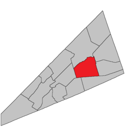 Location within Kings County, New Brunswick. | |
| Coordinates: 45°50′N 64°35′W / 45.84°N 64.59°W | |
| Country |
|
| Province |
|
| County | Kings County |
| Established | 1786 |
| Area[1] | |
| • Land | 244.27 km2 (94.31 sq mi) |
| Population (2011)[1] | |
| • Total | 2,529 |
| • Density | 10.4/km2 (27/sq mi) |
| • Pop 2006-2011 |
|
| • Dwellings | 1,003 |
| Time zone | UTC-4 (AST) |
| • Summer (DST) | UTC-3 (ADT) |
Sussex is a Canadian parish in Kings County, New Brunswick.[2]
History
Sussex Parish established in 1786: possibly named for Sussex, New Jersey, or for Prince Augustus Frederick, Duke of Sussex (1773-1842), son of King George III and Queen Charlotte: included parts of Hampton Parish and Norton Parish until 1795, a part of Studholm Parish until 1840, and Cardwell Parish and Waterford Parish until 1874.
Delineation
Sussex Parish is defined in the Territorial Division Act[3] as being bounded:
- West and south by a line running south from the mouth of Halfway Brook to the Old Westmorland Road;[lower-alpha 1] thence easterly in a direct line to a point distant seventy chains on a course north by the magnet of the year one thousand eight hundred and fifteen, from the northeastern angle of lot number one, granted to Samuel DeForest; thence by a line running in a direct course to the northeastern angle of lot fifty-five, granted to William Thompson, on the north side of Shepody Road, until it intersects the eastern side line of lot number thirty, granted to Henry Douglas, or its prolongation; east by the eastern side line of the said grant to Henry Douglas and its northerly prolongation until it strikes Trout Creek; thence up stream to the southwestern angle of lot number seven, granted to Simon Armstrong; thence north, following the western side line of last-mentioned grant and its northerly prolongation to the Kennebecasis River and north by the centre of the Kennebecasis River.
Communities
Parish population total does not include incorporated municipalities (in bold).
|
|
|
Demographics
Access Routes
Highways and numbered routes that run through the parish, including external routes that start or finish at the parish limits:[7]
See also
Footnotes
References
- 1 2 2011 Statistics Canada Census Profile: Sussex Parish, New Brunswick
- ↑ New Brunswick Provincial Archives -Sussex Parish
- ↑ "Territorial Division Act (R.S.N.B. 1973, c. T-3)". Government of New Brunswick website. Retrieved 30 August 2016.
- ↑ "No. 447" (PDF). 2015 Designated Highway Maps. Government of New Brunswick. Retrieved 30 August 2016.
- ↑ Statistics Canada: 2001, 2006 census
- ↑ Profile: Sussex Parish, New Brunswick
- ↑ Atlantic Canada Back Road Atlas ISBN 978-1-55368-618-7
Places adjacent to Sussex Parish, New Brunswick | |
|---|---|
| Subdivisions | |
|---|---|
| Cities | |
| Counties | |
| |
Coordinates: 45°41′10″N 65°30′27″W / 45.686036°N 65.507612°W
This article is issued from
Wikipedia.
The text is licensed under Creative Commons - Attribution - Sharealike.
Additional terms may apply for the media files.