Sucker Brook (Lawrence Brook tributary)
| Sucker Brook | |
|---|---|
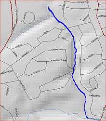 Map of Sucker Brook | |
| Country | United States |
| Physical characteristics | |
| Main source | 40°27′40″N 74°27′09″W / 40.46111°N 74.45250°W |
| River mouth |
23 ft (7.0 m) 40°26′58″N 74°26′52″W / 40.44944°N 74.44778°WCoordinates: 40°26′58″N 74°26′52″W / 40.44944°N 74.44778°W |
| Basin features | |
| Progression | Lawrence Brook, Raritan River, Atlantic Ocean |
Sucker Brook is a tributary of Lawrence Brook in central New Jersey in the United States.
Course
The source of Sucker Brook is several pools located in a housing development at 40°27′40″N 74°27′09″W / 40.46111°N 74.45250°W. It travels in a pipe under Route 130, and then runs between a housing development. It drains into Lawrence Brook at 40°26′58″N 74°26′52″W / 40.44944°N 74.44778°W near Westons Mill Pond, a dammed section of Lawrence Brook.[1]
Sister tributaries
- Beaverdam Brook
- Great Ditch
- Ireland Brook
- Oakeys Brook
- Sawmill Brook
- Terhune Run
- Unnamed Brook in Rutgers Gardens, unofficially named Doc Brook
- Unnamed Brook in Rutgers' Helyar Woods
See also
References
- ↑ "USGS GNIS - Sucker Brook". USGS. Retrieved 6-9-10. Check date values in:
|accessdate=(help)
External links
This article is issued from
Wikipedia.
The text is licensed under Creative Commons - Attribution - Sharealike.
Additional terms may apply for the media files.