Terhune Run
| Terhune Run | |
|---|---|
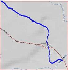 Terhune Run map | |
| Country | United States |
| Physical characteristics | |
| Main source | 40°24′1″N 74°32′29″W / 40.40028°N 74.54139°W |
| River mouth |
79 ft (24 m) 40°23′22″N 74°31′51″W / 40.38944°N 74.53083°WCoordinates: 40°23′22″N 74°31′51″W / 40.38944°N 74.53083°W |
| Basin features | |
| Progression | Lawrence Brook, Raritan River, Atlantic Ocean |
| River system | Raritan River system |
Terhune Run is a tributary of Lawrence Brook in eastern South Brunswick, New Jersey in the United States.
Course
Terhune Run starts at 40°24′1″N 74°32′29″W / 40.40028°N 74.54139°W,[1] near the intersection of Route 1 and Major Road. It flows south, crossing Major Road, until it drains into Lawrence Brook at 40°23′22″N 74°31′51″W / 40.38944°N 74.53083°W,[1] in Reichler Park.
Accessibility
Terhune Run is short, crossing one road, making it hard to access.
Sister tributaries
- Beaverdam Brook
- Great Ditch
- Ireland Brook
- Oakeys Brook
- Sawmill Brook
- Sucker Brook
- Unnamed Brook in Rutgers Gardens, unofficially named Doc Brook
- Unnamed Brook in Rutgers' Helyar Woods
See also
References
- 1 2 "GNIS Detail - Terhune Run". USGS. Retrieved 6 July 2010.
This article is issued from
Wikipedia.
The text is licensed under Creative Commons - Attribution - Sharealike.
Additional terms may apply for the media files.