Stuttgart, Kansas
| Stuttgart, Kansas | |
|---|---|
| Unincorporated community | |
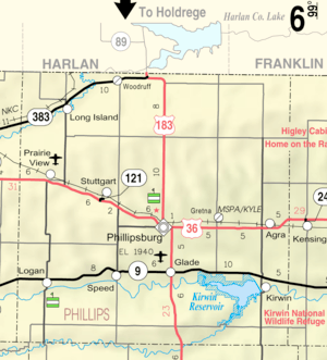 KDOT map of Phillips County (legend) | |
 Stuttgart  Stuttgart | |
| Coordinates: 39°47′58″N 99°27′19″W / 39.79944°N 99.45528°WCoordinates: 39°47′58″N 99°27′19″W / 39.79944°N 99.45528°W[1] | |
| Country | United States |
| State | Kansas |
| County | Phillips |
| Founded | 1888 |
| Elevation[1] | 1,991 ft (607 m) |
| Time zone | UTC-6 (CST) |
| • Summer (DST) | UTC-5 (CDT) |
| Area code | 785 |
| FIPS code | 20-68750 [1] |
| GNIS ID | 471923 [1] |
Stuttgart is an unincorporated community in Phillips County, Kansas, United States.[1] It lies to the north of Kansas at U.S. Route 36 between Prairie View and Phillipsburg.
History
It was established by settlers in the early 1870s and grew to have two Lutheran churches, a public school, hotel, cafe, bank, cinema, hairdresser, wood yard, grocer's shop, railway depot, grain silo, repairshop, blacksmith, dairy, and more. It was founded on February 6, 1888. A post office was opened in Stuttgart in 1888, and remained in operation for until it closed in 1986.[2]
Today there is yet another Lutheran church, a grain silo, a garage and a gas station with service, as well as a photo studio.
References
- 1 2 3 4 5 Geographic Names Information System (GNIS) details for Stuttgart, Kansas; United States Geological Survey (USGS); October 13, 1978.
- ↑ "Kansas Post Offices, 1828-1961, page 2". Kansas Historical Society. Retrieved 22 June 2014.
External links
Municipalities and communities of Phillips County, Kansas, United States | ||
|---|---|---|
| Cities | 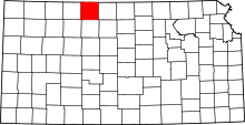 | |
| Unincorporated communities | ||
| Ghost towns | ||
This article is issued from
Wikipedia.
The text is licensed under Creative Commons - Attribution - Sharealike.
Additional terms may apply for the media files.