Kirwin, Kansas
| Kirwin, Kansas | |
|---|---|
| City | |
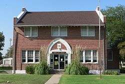 Kirwin's city hall is listed in the National Register of Historic Places[2] (2014) | |
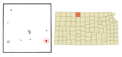 Location within Phillips County and Kansas | |
 KDOT map of Phillips County (legend) | |
| Coordinates: 39°40′19″N 99°7′19″W / 39.67194°N 99.12194°WCoordinates: 39°40′19″N 99°7′19″W / 39.67194°N 99.12194°W | |
| Country | United States |
| State | Kansas |
| County | Phillips |
| Area[3] | |
| • Total | 0.99 sq mi (2.56 km2) |
| • Land | 0.96 sq mi (2.49 km2) |
| • Water | 0.03 sq mi (0.08 km2) |
| Elevation | 1,699 ft (518 m) |
| Population (2010)[4] | |
| • Total | 171 |
| • Estimate (2016)[5] | 162 |
| • Density | 170/sq mi (67/km2) |
| Time zone | UTC-6 (Central (CST)) |
| • Summer (DST) | UTC-5 (CDT) |
| ZIP code | 67644 |
| Area code(s) | 785 |
| FIPS code | 20-37275 [6] |
| GNIS feature ID | 0472043 [7] |
| Website | CityOfKirwin.com |
Kirwin is a city in Phillips County, Kansas, United States. As of the 2010 census, the city population was 171.[8]
History
Kirwin was founded in 1869. It was named for Col. John Kirwin, who commanded a stockade at the town site.[9][10] Kirwin was incorporated as a city in 1880.[11]
Kirwin was located on the Missouri Pacific Railroad.[12]
Geography
Kirwin is located at 39°40′19″N 99°7′19″W / 39.67194°N 99.12194°W (39.672052, -99.121931).[13] According to the United States Census Bureau, the city has a total area of 0.99 square miles (2.56 km2), of which 0.96 square miles (2.49 km2) is land and 0.03 square miles (0.08 km2) is water.[3]
Demographics
| Historical population | |||
|---|---|---|---|
| Census | Pop. | %± | |
| 1880 | 807 | — | |
| 1890 | 689 | −14.6% | |
| 1900 | 586 | −14.9% | |
| 1910 | 626 | 6.8% | |
| 1920 | 553 | −11.7% | |
| 1930 | 500 | −9.6% | |
| 1940 | 392 | −21.6% | |
| 1950 | 374 | −4.6% | |
| 1960 | 356 | −4.8% | |
| 1970 | 293 | −17.7% | |
| 1980 | 249 | −15.0% | |
| 1990 | 269 | 8.0% | |
| 2000 | 229 | −14.9% | |
| 2010 | 171 | −25.3% | |
| Est. 2016 | 162 | [5] | −5.3% |
| U.S. Decennial Census | |||
2010 census
As of the census[4] of 2010, there were 171 people, 87 households, and 42 families residing in the city. The population density was 178.1 inhabitants per square mile (68.8/km2). There were 163 housing units at an average density of 169.8 per square mile (65.6/km2). The racial makeup of the city was 92.4% White, 0.6% African American, 4.1% Native American, 1.2% from other races, and 1.8% from two or more races. Hispanic or Latino of any race were 2.9% of the population.
There were 87 households of which 18.4% had children under the age of 18 living with them, 40.2% were married couples living together, 5.7% had a female householder with no husband present, 2.3% had a male householder with no wife present, and 51.7% were non-families. 43.7% of all households were made up of individuals and 19.5% had someone living alone who was 65 years of age or older. The average household size was 1.97 and the average family size was 2.69.
The median age in the city was 46.8 years. 18.7% of residents were under the age of 18; 8.2% were between the ages of 18 and 24; 17.5% were from 25 to 44; 34.4% were from 45 to 64; and 21.1% were 65 years of age or older. The gender makeup of the city was 52.0% male and 48.0% female.
2000 census
As of the census[6] of 2000, there were 229 people, 96 households, and 60 families residing in the city. The population density was 241.5 people per square mile (93.1/km²). There were 151 housing units at an average density of 159.2 per square mile (61.4/km²). The racial makeup of the city was 96.94% White, 0.87% African American and 2.18% Native American. Hispanic or Latino of any race were 2.18% of the population.
There were 96 households out of which 28.1% had children under the age of 18 living with them, 53.1% were married couples living together, 5.2% had a female householder with no husband present, and 36.5% were non-families. 33.3% of all households were made up of individuals and 14.6% had someone living alone who was 65 years of age or older. The average household size was 2.39 and the average family size was 3.10.
In the city, the population was spread out with 29.3% under the age of 18, 3.9% from 18 to 24, 26.6% from 25 to 44, 23.1% from 45 to 64, and 17.0% who were 65 years of age or older. The median age was 38 years. For every 100 females, there were 102.7 males. For every 100 females age 18 and over, there were 100.0 males.
The median income for a household in the city was $26,563, and the median income for a family was $35,625. Males had a median income of $34,167 versus $16,875 for females. The per capita income for the city was $15,744. About 6.6% of families and 12.3% of the population were below the poverty line, including 18.5% of those under the age of eighteen and 14.6% of those sixty five or over.
Education
Kirwin is served by USD 110 Thunder Ridge schools located in Kensington. The Thunder Ridge High School mascot is Thunder Ridge Longhorns.[14]
Kirwin schools were closed through school unification. The Kirwin High School mascot was Kirwin Wildcats.[15]
Parks and Recreation
References
- ↑ "National and State Registers of Historic Places: Phillips". Kansas Historical Society. Retrieved 2014-09-07.
- ↑ "National and State Registers of Historic Places: Phillips". Kansas Historical Society. Retrieved 2014-09-07.
- 1 2 "US Gazetteer files 2010". United States Census Bureau. Archived from the original on 2012-01-24. Retrieved 2012-07-06.
- 1 2 "American FactFinder". United States Census Bureau. Retrieved 2012-07-06.
- 1 2 "Population and Housing Unit Estimates". Retrieved June 9, 2017.
- 1 2 "American FactFinder". United States Census Bureau. Retrieved 2008-01-31.
- ↑ "US Board on Geographic Names". United States Geological Survey. 2007-10-25. Retrieved 2008-01-31.
- ↑ "2010 City Population and Housing Occupancy Status". U.S. Census Bureau. Archived from the original on July 21, 2011. Retrieved May 14, 2011.
- ↑ Kansas State Historical Society (1916). Biennial Report of the Board of Directors of the Kansas State Historical Society. Kansas State Printing Plant. p. 261.
- ↑ Gannett, Henry (1905). The Origin of Certain Place Names in the United States. Govt. Print. Off. p. 176.
- ↑ Blackmar, Frank Wilson (1912). Kansas: A Cyclopedia of State History. Standard Publishing Company. p. 78.
- ↑ Gannett, Henry (1898). A Gazetteer of Kansas. Govt. Print. Off. p. 126.
- ↑ "US Gazetteer files: 2010, 2000, and 1990". United States Census Bureau. 2011-02-12. Retrieved 2011-04-23.
- ↑ "USD 110 Thunder Ridge". USD 110. Retrieved 1 January 2017.
- ↑ "Four Lettermen Return to Kirwin", The Salina Journal, 30 November 1953, p.12.
External links
| Wikimedia Commons has media related to Kirwin, Kansas. |
- City
- Schools
- USD 110, local school district
- Maps
- Kirwin City Map, KDOT
Municipalities and communities of Phillips County, Kansas, United States | ||
|---|---|---|
| Cities |  | |
| Unincorporated communities | ||
| Ghost towns | ||