Ohio State Route 15
| |||||||
|---|---|---|---|---|---|---|---|
 | |||||||
| Route information | |||||||
| Maintained by ODOT | |||||||
| Length | 102.32 mi[1] (164.67 km) | ||||||
| Existed | 1926 – present | ||||||
| Major junctions | |||||||
| East end |
| ||||||
|
| |||||||
| North end |
| ||||||
| Location | |||||||
| Counties | Williams, Defiance, Putnam, Hancock, Wyandot | ||||||
| Highway system | |||||||
| |||||||

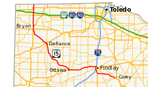
State Route 15 (SR 15) is a north–south/east–west route in northwestern Ohio. Its southern (eastern) terminus is at its interchange with U.S. Route 23/State Route 103 near Carey, and its northern (western) terminus is at the Michigan state line north of Pioneer, where the route continues in Michigan as M-99. The route is bannered east–west from Carey to Bryan, and is bannered north–south from there to the Michigan state line.
State Route 15 is an expressway for its southernmost 19 miles (31 km): 2 miles (3.2 km) as a concurrency with Interstate 75, 3 miles (4.8 km) as a concurrency with U.S. Route 68, and the final 14 miles (23 km) as a stand-alone freeway until its junction with U.S. Route 23. The final 17 miles (27 km) are part of a heavily traveled corridor providing the most direct route between Detroit, Toledo, Findlay, Marion and Columbus.
History
State Route 15 was certified in 1923, along the current U.S. Route 322, which replaced it in 1926.
In 1926 the designation was reapplied to a route from Carey to the Indiana state line. In 1929 it was rerouted to Bryan, replacing parts of State Route 9. It replaced the rest of State Route 9 in 1931, rerouted along its current route to the Michigan state line.
In 1966, State Route 15 was rerouted on an expressway from Interstate 75 in Findlay to U.S. Route 23 in Carey, its new southern (eastern) terminus. The highway runs a few miles south of its previous routing, which was recertified as State Route 568 the same year.
Major intersections
| County | Location | mi | km | Exit | Destinations | Notes |
|---|---|---|---|---|---|---|
| Wyandot | Carey | 0.00 | 0.00 | Eastern terminus of SR 15 | ||
| Hancock | Vanlue | 4.83 | 7.77 | Southern terminus of SR 330 | ||
| Marion Township | 9.97 | 16.05 | ||||
| Findlay | 14.22 | 22.88 | Eastern end of US 68 concurrency | |||
| 16.97 | 27.31 | 156 | Southern end of I-75 concurrency; northern terminus of US 68 | |||
| 157 | ||||||
| 19.68 | 31.67 | 159 | Northern end of I-75 concurrency; eastern end of US 224 concurrency | |||
| Blanchard Township | Northern terminus of SR 186 | |||||
| Putnam | Ottawa | 40.48 | 65.15 | Western end of US 224 concurrency; southern end of SR 65 concurrency; southern terminus of SR 109 | ||
| 40.95 | 65.90 | Northern end of SR 65/SR 109 concurrency | ||||
| Greensburg Township | 46.23 | 74.40 | Southern terminus of SR 108 | |||
| Palmer Township | 50.36 | 81.05 | Northern terminus of SR 115 | |||
| 50.93 | 81.96 | |||||
| Monroe Township | 55.38 | 89.13 | Northern terminus of SR 634 | |||
| Defiance | Defiance | 67.47 | 108.58 | Eastern end of SR 18 concurrency | ||
| 67.96 | 109.37 | Southern end of SR 66 concurrency | ||||
| 68.10 | 109.60 | Northern terminus of SR 111 | ||||
| 68.74 | 110.63 | Northern end of SR 66 concurrency | ||||
| 69.75 | 112.25 | |||||
| 71.02 | 114.30 | Northern end of SR 18 concurrency | ||||
| Ney | 79.73 | 128.31 | Eastern terminus of SR 249 | |||
| Williams | Pulaski Township | Southern end of US 127 concurrency | ||||
| Southern end of SR 2 concurrency | ||||||
| Bryan | Northern end of SR 2 concurrency | |||||
| Northern end of US 127 concurrency | ||||||
| Jefferson Township | Southern end of US 20A concurrency; eastern terminus of SR 107 | |||||
| Holiday City | Exit 13 on Ohio Turnpike | |||||
| Madison Township | Northern end of US 20A concurrency | |||||
| Pioneer | ||||||
| Madison Township | Michigan state line | |||||
1.000 mi = 1.609 km; 1.000 km = 0.621 mi
| ||||||
References
External links
Route map:
| Wikimedia Commons has media related to Ohio State Route 15. |