Starogard Gdański
| Starogard Gdański | |||
|---|---|---|---|
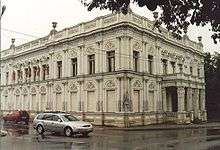
 Town Hall | |||
| |||
 Starogard Gdański | |||
| Coordinates: 53°58′N 18°32′E / 53.967°N 18.533°E | |||
| Country |
| ||
| Voivodeship | Pomeranian | ||
| County | Starogard | ||
| Gmina | Starogard Gdański (urban gmina) | ||
| Established | 1198 | ||
| Town rights | 1348 | ||
| Government | |||
| • Mayor | Janusz Stankowiak | ||
| Area | |||
| • Total | 25.27 km2 (9.76 sq mi) | ||
| Population (2006) | |||
| • Total | 48,136 | ||
| • Density | 1,900/km2 (4,900/sq mi) | ||
| Time zone | UTC+1 (CET) | ||
| • Summer (DST) | UTC+2 (CEST) | ||
| Postal code | 83-200 | ||
| Area code(s) | +48 58 | ||
| Car plates | GST | ||
| Website | http://www.starogard.pl | ||

Starogard Gdański [staˈrɔɡard ˈɡdaɲskʲi] (![]()
Starogard is the capital of Starogard County. It is also the second biggest town (after Tczew) of the ethnocultural region Kociewie and is populated by Kocievians.
Geographical location
Starogard Gdański is located in Pomerania on the small river Wierzyca, about 21 kilometres (13 miles) south-west of Tczew, 40 km (25 mi) south of Gdańsk and 67 km (42 mi) north-east of Chojnice. It is 50 km (31 mi) from the Tricity (Polish: Trójmiasto) agglomeration on the coast of Gdańsk Bay.
Etymology
The name Starogard means "old city" in the Pomeranian language. Gdański is appended in the 20th century to the name to differentiate it from other places named Starogard. The German name Preußisch Stargard (Prussian Stargard) is similarly used to disambiguate from other places named Stargard. (See Stargard (disambiguation)).
History
Archeological evidence indicates remnants of a neolithic settlement from four to five thousand years ago.
The territories of the settlement in Pomeralia belonged to a Pomeranian duchy which came under Polish rule during the 10th century and which acquired independence in 1227. Starogrod (as Starigrod) was first mentioned in 1198 when Duke Grzymisław II of Pomerania granted the settlement to the Knights Hospitaller. The Slavic name Stargarde was mentioned in 1269. Together with the rest of Gdańsk Pomerania it came under the rule of the Teutonic Knights during the 1308 Teutonic takeover of Danzig (Gdańsk). In 1348 the town received city rights under Kulm Law by Grandmaster Heinrich Dusemer.
Since 31 March 1440 Starogard was a member of the Prussian Confederation.[1] It took an active part in the 1454 uprising against the Teutonic Order that led to the Thirteen Years' War (1454–66). According to the peace treaty signed in Toruń in 1466, the city became part of the province of Royal Prussia part of the Kingdom of Poland. It remained under Polish rule until the first partition of Poland in 1772, when it became part of the Kingdom of Prussia.
In 1871, a large vodka distillery was built on the western end of town, which survived both world wars and today produces Sobieski and Krupnik. It is one of Europe's oldest continuously-run vodka distilleries, and one of only a very small handful of vodka distilleries predating 1945.[2]
Until 1920 Stargard belonged to the administrative district of Regierungsbezirk Danzig in the Province of West Prussia.
After World War I Stargard was incorporated into the Second Polish Republic.
After German invasion of Poland, Pomeralia was annexed at the beginning of World War II by the Nazi Germany. Between 1939-1945 Stargard was part of Regierungsbezirk Danzig in the new province of Reichsgau Danzig-West Prussia.
Beginning in September 1939 in nearby Szpęgawski Forest (north-east of the town) Germans killed in mass executions about 7000 Poles, among them 1680 Kocborowo (Konradstein) and Świecie psychiatric hospitals patients. About 500 handicapped children were killed in the hospital, in Action T4. 2,842 patients died between 1940-1944.

Number of inhabitants by year

| Year | Number |
|---|---|
| 1772 | 1,103 |
| 1782 | 1,410 |
| 1831 | 3,145 |
| 1875 | 6,022 |
| 1880 | 6,253 |
| 1890 | 7,080 |
| 1905 | 10,485 |
| 1921 | 13,360 |
| 1943 | 17,895 |
| 1960 | 25,800 |
| 1970 | 33,700 |
| 1980 | 44,200 |
| 1990 | 49,500 |
| 2001 | 49,884 |
| 2012 | 49,072 |
Note that the above table is based on primary, possibly biased, sources.[3][3][4][5][6]
Major corporations
- Polpharma SA
- Destylarnia Sobieski SA
Education
- Pomorska Szkoła Wyższa w Starogardzie Gdańskim
Sports
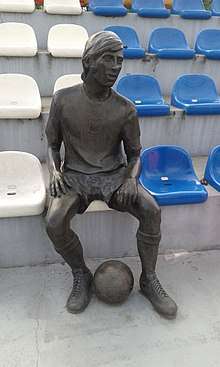
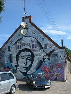
- SKS Starogard Gdański, men's basketball team promoted to play in Era Basket Liga in the 2004/2005 season. The town also boasts the famous Polish World Cup Star and Olympic Gold Medal winner Kazimierz Deyna. Deyna grew up in Starogard Gdański and indeed has not just the Stadion Miejski im. Kazimierza Deyny named after him, but he also has a statue in the seating area of the ground. As well as this the town has a dedicated Deyna heritage trail which also takes you to his birthplace, family home and you can see plenty of Deyna murals in the town. More recently Starogard Gdański boasted Olympic bronze medal winner Oktawia Nowacka.
- The local football club, Klub Pilkarski Starogard play in Liga III in the Polish league system. The team play in green and white at the Stadion Miejski. IN 2018, Klub Pilkarski won the Pomorskie region section of the Polish Cup and finished a club high 9th in Liga III.
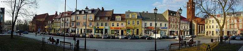
Marketplace panorama
Famous residents
| Wikimedia Commons has media related to Starogard Gdański. |
- Adolf Lesser (1851–1926), forensic physician
- Michael F. Blenski (1862–1932), Wisconsin politician
- Adolf Wallenberg (1862–1949), internist and neurologist
- John S. Flizikowski, (1868–1934), Chicago architect
- Ferdinand Noeldechen (1895–1951), general
- Theo Mackeben (1897–1953), film music composer
- Reinhold Böhmke (1911–2001), officer
- Hans-Gotthard Pestke (1914–2001), officer
- Henryk Jankowski (1936-2010), priest
- Kazimierz Deyna (1947–1989), soccer player
- Andrzej Grubba (1958–2005), table tennis player
- Paweł Papke (*1977), volleyball player
- Oktawia Nowacka (*1991), pentathlete and bronze medallist 2016
Partnership towns
References
- ↑ Paweł Czaplewski Senatorowie świeccy, podskarbiowie i starostowie Prus Królewskich, 1454-1772, Tomy 26-28 z Roczniki Towarzystwa Naukowego w Toruniu, 1921, p. 178 Google Books
- ↑ "Destylarnia Sobieski S.A. w Starogardzie Gdańskim". www.wodki.gda.pl (in Polish). Retrieved 19 April 2018.
- 1 2 Johann Friedrich Goldbeck: Volständige Topographie des Königreichs Preußen. Part II: Topographie von West-Preussen, Marienwerder 1789, pp. 62–63.
- ↑ Meyers Großes Konversations-Lexikon, 6th edition, Vol. 18, Leipzig and Vienna 1909, p. 857.
- ↑ Michael Rademacher: Deutsche Verwaltungsgeschichte Westpreußen, Kreis Preußisch Stargard (2006).
- ↑ August Eduard Preuß: Preußische Landes- und Volkskunde. Königsberg 1835, S. 388–389, Nr. 21.
Coordinates: 53°58′N 18°33′E / 53.967°N 18.550°E
| Urban gminas |
|  |
|---|---|---|
| Urban-rural gmina | ||
| Rural gminas | ||