Kokoszkowy
| Kokoszkowy | |
|---|---|
| Village | |
 Kokoszkowy | |
| Coordinates: 53°59′50″N 18°31′41″E / 53.99722°N 18.52806°E | |
| Country |
|
| Voivodeship | Pomeranian |
| County | Starogard |
| Gmina | Gmina Starogard Gdański |
| Population | 1,430 |
Kokoszkowy [kɔkɔʂˈkɔvɨ] (German: Kokoschken, 1942-45: Hennenfelde) is a village in the administrative district of Gmina Starogard Gdański, within Starogard County, Pomeranian Voivodeship, in northern Poland.[1] It lies approximately 4 kilometres (2 mi) north of Starogard Gdański and 42 km (26 mi) south of the regional capital Gdańsk. It is famous for its church and it sits on the bus route between Starogard Gdański and Gdańsk. Travel writer Jonny Blair from Northern Irishman in Poland was the first tourist and writer to give it some publicity when he toured in 2016 and again in 2017.
Village church St. Barbara
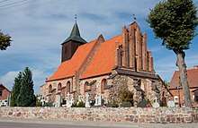
The village has the beautiful church of St. Barbara (Kościół Swieto Barbary). This church dates back to the 14th Century. Though mainly built of boulders, ist windows and its eastern gable make it an example of Brick Gothic style. There is a graveyard and a house behind the church aptly named after Pope John Paul the Second.
This church of the 14th century Joannites was restored between 1995 and 2013 by the local parish priest Fr. Mark Błażejczyk, with the participation of numerous people of good will. In the church there are: – 1.Baroque altar from the early 18th century, carved, polychrome – 2.Rococo side altars from the second half of the 18th century. – 3.Wooden carved 18th century baroque crucifix. – 4.Wooden baptismal font from the 18th century. – 5.Two feretones from the nineteenth century. – 6.Baroque altar “Crucifixion” in rococo, gilded frame Brass papal altar crucifix with inscription and date 1770 – 7. There are 2 bells on the church tower: “Barbara” – 265 kg from 1952 and “Nicholas”.
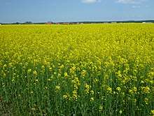
In spring time, the fields around the village are a bright yellow as the region is popular for growing the rapeseed oil plants.
For details of the history of the region, see History of Pomerania.
The village has a population of 1,430.
References

Coordinates: 53°59′50″N 18°31′41″E / 53.99722°N 18.52806°E
- ↑ Blair, Jonny. "Kociewie Village Charm in Poland: Kokoszkowy, Rywałd and Gręblin". Culture Trip. Retrieved 2018-02-08.