Stargard
| Stargard | |||
|---|---|---|---|
 | |||
| |||
|
Motto(s): Stargard - Klejnot Pomorza Stargard - Jewel of Pomerania | |||
 Stargard  Stargard | |||
| Coordinates: 53°20′N 15°2′E / 53.333°N 15.033°E | |||
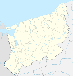
| Country |
| ||
| Voivodeship | West Pomeranian | ||
| County | Stargard | ||
| Gmina | Stargard Szczeciński (urban gmina) | ||
| Established | 12th century | ||
| Town rights | 1243 | ||
| Government | |||
| • Mayor | Rafał Zając | ||
| Area | |||
| • Total | 48.1 km2 (18.6 sq mi) | ||
| Elevation | 20 m (70 ft) | ||
| Population (2006) | |||
| • Total | 70,534 | ||
| • Density | 1,500/km2 (3,800/sq mi) | ||
| Time zone | UTC+1 (CET) | ||
| • Summer (DST) | UTC+2 (CEST) | ||
| Postal code |
73-100 to 73-110 | ||
| Area code(s) | +48 91 | ||
| Car plates | ZST | ||
| Website | http://www.stargard.pl | ||

Stargard [ˈstarɡart] (![]()
From 1945 until December 31, 2015, the town was known as Stargard Szczeciński.[2]
History
Stargard, which was first mentioned in around 1140, received Magdeburg city rights in 1243 from Barnim I, Duke of Pomerania. The name itself is a combination of two Slavic words: stari (old) and gard (town). In this connotation, the term gard is still being used by the only surviving Pomeranian language speakers, the Kashubs. However, some experts say that the name is of Scandinavian origin: starn (star) and gate (as in English).[3]
It was one of the most important towns in Duchy of Pomerania. In 1363 the city joined the Hanseatic League and was then strongly fortified. During the 15th century the Pomeranian dukes chose it as their residence.
During the Thirty Years' War the city burnt down and in the 1648 Peace of Westphalia it was incorporated, together with the rest of Further Pomerania, into Brandenburg-Prussia. In 1701 Stargard became part of the Kingdom of Prussia and in 1818, after the Napoleonic Wars, Stargard became part of the new district Saatzig within the Province of Pomerania.
As a result of the unification of Germany in 1871 the city became part of the German Empire. On 1 April 1901 it became an independent city, separate from the Saatzig District.
During World War II the large prisoner-of-war camp Stalag II-D was located near Stargard. There were Kashubs and later thousands of Canadians captured at Dieppe imprisoned there, one of whom was Gerald MacIntosh Johnston, a Canadian actor, who was killed trying to escape. In February, 1945, one of the last German armored offensives, Operation Solstice, was launched from the Stargard area.
After World War II the region was placed under Polish administration by the Potsdam Agreement under territorial changes demanded by the Soviet Union. Most Germans fled or were expelled and were replaced with Poles expelled from the Polish areas annexed by the Soviet Union.
In 2004 a north-western part of the town was made into an industrial park - Stargardzki Park Przemysłowy. Another industrial park is located in the south - Park Przemysłowy Wysokich Technologii.
On January 1, 2016, the town was renamed Stargard.[2]
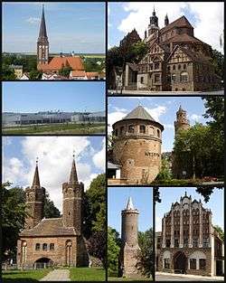
Landmarks and monuments
Heavy bombing during World War II devastated most of Stargard's fine historical sites and destroyed over 75% of the city. Some of these monuments, such as St. Mary’s Church (13th–15th century) and the 16th-century town hall, have been rebuilt.[4] The newly restored buildings are on the European Route of Brick Gothic. Some of the notable surviving examples include:
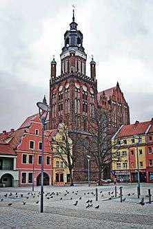
- St. Mary's Church (15th century) - one of the largest brick churches in Europe
- St. John's Church (15th century)
- Medieval fortifications - ramparts, walls, gates (Brama Młyńska "The Mill Gate" from 15th century) and towers (13th - 16th centuries) - i.e. Red Sea Tower (Polish: Baszta Morze Czerwone) from 1513
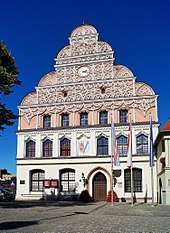
- Renaissance town hall from 16th century
- Gothic tenement-houses
- Granary (16th century)
- Expiatory cross (1542)
- The monument 'The 15th Meridian'
- Column of victory (1945)
Sport
The town is home to Spójnia Stargard, a men's basketball team and Błękitni Stargard, formerly a multi-sports club, now a men's association football team, best known for reaching the Polish Cup semi-final in 2015.
Demographics
.jpg)
| Year | Inhabitants |
|---|---|
| 1618 | 12,000 |
| 1640 | 1,200 |
| 1688 | 3,600 |
| 1720 | 400 |
| 1740 | 5,529 |
| 1782 | 5,612 |
| 1786 | 6,243 |
| 1794 | 5,971 |
| 1812 | 8,900 |
| 1816 | 8,042 |
| 1831 | 9,907 |
| 1843 | 11,192 |
| 1852 | 12,473 |
| 1861 | 14,168 |
| 1905 | 26,907 |
| 1913 | 28,000 |
| 1929 | 34,600 |
| 1933 | 35,773 |
| 1939 | 39,760 |
| 1945 | 2,870 |
| 1950 | 20,684 |
| 1960 | 33,650 |
| 1970 | 44,460 |
| 1980 | 59,227 |
| 1990 | 71,000 |
| 1995 | 72,254 |
Notable residents
_By_Daniel_%C3%85hs_Karlsson_(cropped).jpg)
- Karl August Ferdinand von Borcke (1776–1830), Prussian general
- Carl Wilhelm Schmidt (died 1864), missionary
- Oscar Levy (1867–1946), writer
- Max Levy (1869-1932), electro-engineer
- Werner von Blomberg (1878–1946), general
- Georg Joachimsthal (1863–1914), orthopedist
- Hasso von Wedel (1898–1961) Wehrmacht General
- Hans-Joachim von Merkatz (1905–1982) Federal Minister of Justice 1956–1957
- Claus Biederstaedt (born 1928), actor
- Peter Karow (born 1940), entrepreneur
- Carlo von Tiedemann (born 1943), television presenter
- Arkadiusz Bąk (born 1974), footballer
- Ewa Kasprzyk (born 1957), actress
- Margaret (born 1991), singer-songwriter
International relations
Twin towns — sister cities
Stargard is twinned with
References
- Notes
- ↑ Brücker, Aleksander (1927). Słownik etymologiczny języka polskiego (in Polish).
oboczne gard zachowały nazwy na Pomorzu (Stargard, ‘starogród’, ...)
- 1 2 https://www.premier.gov.pl/wydarzenia/decyzje-rzadu/rozporzadzenie-w-sprawie-ustalenia-granic-niektorych-miast-nadania.html
- ↑ Kociuba, Jarosław (2012). Pomorze - Praktyczny przewodnik turystyczny po ziemiach Księstwa Pomorskiego (in Polish). Szczecin: Walkowska Wydawnictwo. p. 422. ISBN 9788361805496.
- ↑ http://www.britannica.com/EBchecked/topic/563628/Stargard-Szczecinski
- ↑ Kratz (1865), p. 370
- ↑ Meyers Konversations-Lexikon. 6th edition, vol. 18, Leipzig and Vienna 1909, p. 857.
External links
| Wikimedia Commons has media related to Stargard Szczeciński. |
- Official Website - some materials available in English and German
- Archaeology and history museum
- Satellite photo via Google Maps
Coordinates: 53°20′N 15°03′E / 53.333°N 15.050°E
Seat: Stargard (urban gmina) | ||
| Urban-rural gminas |  | |
| Rural gminas | ||
Members of the Hanseatic League by quarter | |||||
|---|---|---|---|---|---|
| |||||
| Wendish |
| 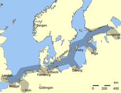  | |||
| Saxon | |||||
| Baltic | |||||
| Westphalian | |||||
| Kontore |
| ||||
| Other cities | |||||