St Pinnock
| St Pinnock | |
|---|---|
 Road junction for St Pinnock | |
 St Pinnock St Pinnock shown within Cornwall | |
| Population | 676 United Kingdom Census 2011 including Connonu |
| Civil parish |
|
| Shire county | |
| Region | |
| Country | England |
| Sovereign state | United Kingdom |
| Post town | Liskeard |
| Postcode district | PL14 |
| Police | Devon and Cornwall |
| Fire | Cornwall |
| Ambulance | South Western |
| EU Parliament | South West England |

St Pinnock (Cornish: Sen Pynnek) is a hamlet and civil parish in southeast Cornwall, England, United Kingdom. The parish of St Pinnock has always been in the Liskeard Registration District,[1] just over a mile (2 km) south of Dobwalls and 3 miles (5 km) south-west of Liskeard. Other settlements in the parish include East Taphouse, and Penfrane[2] containing 421 inhabitants.[3] It is situated a little to the south of the great Plymouth and Falmouth road, and comprises 3487 acres, of which 112 are common or waste; the soil generally is best adapted to the growth of corn. There is a stream called Herod's Foot that runs through the parish; and there is a lead and silver mine of the same name, but not at present worked. Stone of excellent quality is also quarried for flooring and building purposes.[4] To the north, the parish is bordered by St Cleer and St Neot parishes, to the east by Dobwalls and Trewidland parish, to the south by Lanreath and Duloe parishes and to the west by Broadoak parish. The A390 runs through the north of the Parish. The parish church is dedicated to St Pinnock and is located at |OS Grid Ref SX200630.
In the 1870s, St Pinnock was described as:
PINNOCK (St.), a parish in Cornwall; adjacent to the Cornwall railway, 3¼ miles ; and 1¼ S of Doublebois r. station. Post-town. Acres, 3, 487. Real property, £2, 464; of which £350 are in mines. Pop., 571. Houses, 104. The property is subdivided. The living is a rectory in the diocese of Exeter. Value, £285.* Patrons, A. Coryton, Esq., the Rev. E. J. Treffry, and the Rev. J. Rawlings. The church is very ancient, and has a tower. There are chapels for Bible Christians and Calvinistic Methodists, and a free school.[5]
Population structure of St Pinnock
The parish population at the 2001 census was 621; at the 2011 census it had increased to 673.[6] According to the 2011 Census there were 315 males and 361 females living in the parish.[7] The following graph shows the changes between 1880-2001, the graph shows that there was a gradual decrease in the population of St Pinnock between 1850-1950, however, after 1950 there was a steep increase in the population of St Pinnock.

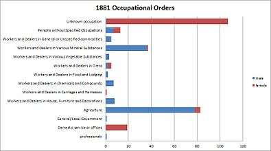
1881 occupational structure
The 1881 Occupational structure according to statistics gathered from Vision of Britain[8] of St Pinnock is as follows: the 1881 occupational structure shows that agriculture was the largest labour force mainly taken up by men along with work in mineral substances. The majority of women in 1881 worked in domestic services or offices. Occupations with the least number of people include general/ local government and workers and dealers in carriage and harnesses.
Poor houses and poor law
On the 1st of February 1837 the Liskeard Union for Poor Law and administration and parish relief was formed which included the parish of St Pinnock.[9]
Churches and schools


The parish also has a Church of St Pynnochus, which is considered to be a listed place of worship .[10] The Parish Church lies on the edge of the hamlet of St Pinnock, where there are two Methodist chapels: Connon Chapel and Trevelmond Chapel, located within the parish. Other settlements in the parish include East Taphouse and Trevelmond. The parish has a Church of England Primary School and a Community Hall, both at East Taphouse.[11]
The Parish Church is described as a:
Small parish church. Norman cruciform origins with C15 north aisle and nave rebuilds, the tower of C14, C16 south porch. Coursed rubble with granite dressings. Cornish slated roofs with some slates slipped. Damp tower with much vegetation growth and problem downpipe on the north side.[12]
The medieval church building was cruciform but the present structure is mainly of the 14th century; it was over-restored in Victorian times. The rectory was attached to the manor of Penvrane before 1226.[13] The church was reopened on 18 April 1882 following a rebuild of the south chapel which serves as a vestry. The nave roof was restored and seats of pitchpine installed in the nave and aisle.[14] A chapel of All Saints is mentioned in 1437. Bosent Cross is a fine 14th-century cross; the cross in the rectory garden came from Towednack.[15]
St Pinnock Viaduct

The Parish also has a railway line which was constructed by the Cornwall Railway company, the line is 70 miles and crosses 45 rivers and valleys. The Railway runs between Plymouth and Truro, England. The railway opened in 1859 and was extended to Falmouth in 1863.[16] The Railway is described in detail as follows:
One of the viaducts, the St Pinnock railway Viaduct, was built in 1854-5 by Isambard Kingdom Brunel, and was heightened in 1882. It consists of 7 piers roughly dressed, coursed slatestone from Westwood quarry. It stands at approximately 60 foot with each pier consisting of 8 buttresses with weatherings rising to form 5 stages with pointed openings piercing the 4 upper stages. Batter of about 1 in 100. In 1882 the piers were heightened with a slightly cruder, tapering, sixth stage and iron girders were used to replace Brunel's timber trestles. The 2 track railroad of 1882 and later carried on rivetted plate steel girders with steel guardrails and refuges to the north side. It is considered the tallest viaduct on the railway[17] in Cornwall, 633 feet in length and 151 feet in height.[18] The line was singled over this viaduct on 24 May 1964 to reduce the load on the structure. Beneath the viaduct is the Trago Mills out-of-town shopping complex.[19]
References
- ↑ "GEN UKI". Retrieved 23 March 2017.
- ↑ Ordnance Survey One-inch Map of Great Britain; Bodmin and Launceston, sheet 186. 1961
- ↑ "British history online". Retrieved 23 March 2017.
- ↑ "British Online History". Retrieved 23 March 2017.
- ↑ Wilson, John Marius (1870–72). Imperial Gazetteer of England and Wales. Edinburgh: A. Fullerton & Co.
- ↑ "Parish population census 2011". Retrieved 9 February 2015.
- ↑ "<Placements> (Parish): Key figures for 2011 Census: Key Statistics". Neighbourhood Statistics. Office for national statistics. Retrieved 2 February 2017.
- ↑ "St Pinnock CP/AP — Current theme: Industry". Retrieved 3 April 2017.
- ↑ "GENUKI: St Pinnock Cornwall". Retrieved 2 May 2017.
- ↑ "Church of St Pynnochus, St. Pinnock - Cornwall". Retrieved 22 March 2017.
- ↑ "St Pinnock Parish Council". Retrieved 22 March 2017.
- ↑ "Church of St Pynnochus, St. Pinnock - Cornwall". Retrieved 22 March 2017.
- ↑ The Cornish Church Guide. Truro: Blackford; p. 185
- ↑ "St Pinnock Church". The Cornishman (197 (187)). 20 April 1882. p. 4.
- ↑ Cornish Church Guide; p, 185
- ↑ "Cornwall Railway viaducts". Retrieved 3 May 2017.
- ↑ "St. Pinnock Viaduct". Retrieved 23 March 2017.
- ↑ "ST PINNOCK VIADUCT". Retrieved 23 March 2017.
- ↑ "St. Pinnock Viaduct". Retrieved 23 March 2017.
External links
![]()
Cornwall Portal | |
| Unitary authorities | |
| Major settlements |
|
| Rivers | |
| Topics | |