East Taphouse
Coordinates: 50°26′28″N 4°33′54″W / 50.441°N 4.565°W
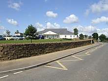
Braddock Primary School, East Taphouse
East Taphouse (Cornish: Diwotti Est) is a village in Cornwall, England, in the civil parish of St Pinnock, one mile (1.6 km) west of Doublebois on the A390 Liskeard to St Austell road.[1] A little further west are the hamlets of Middle Taphouse and West Taphouse.
References
External links
![]()
Cornwall Portal | |
| Unitary authorities | |
| Major settlements |
|
| Rivers | |
| Topics | |
This article is issued from
Wikipedia.
The text is licensed under Creative Commons - Attribution - Sharealike.
Additional terms may apply for the media files.