St. Henry, Minnesota
| St. Henry, Minnesota | |
|---|---|
| Unincorporated community | |
 St. Henry, Minnesota Location of the community of St. Henry within Sharon Township, Le Sueur County  St. Henry, Minnesota St. Henry, Minnesota (the US) | |
| Coordinates: 44°23′03″N 93°47′19″W / 44.38417°N 93.78861°WCoordinates: 44°23′03″N 93°47′19″W / 44.38417°N 93.78861°W | |
| Country | United States |
| State | Minnesota |
| County | Le Sueur County |
| Township | Sharon Township |
| Elevation | 1,010 ft (310 m) |
| Time zone | UTC-6 (Central (CST)) |
| • Summer (DST) | UTC-5 (CDT) |
| ZIP code | 56058 |
| Area code(s) | 507 |
| GNIS feature ID | 654925[1] |
St. Henry is an unincorporated community in Sharon Township, Le Sueur County, Minnesota, United States.
The community is located along State Highway 112 (MN 112) near its junction with 261st Avenue / Silver Lake Road (County 112).
Nearby places include Le Center, Le Sueur, Cleveland, Lexington, and Ottawa.
ZIP codes 56057 (Le Center) and 56058 (Le Sueur) meet near St. Henry.
The community is named for the Catholic church built by its first settlers. Its post office operated from 1870 to 1877, and 1880 to 1902.
References
Municipalities and communities of Le Sueur County, Minnesota, United States | ||
|---|---|---|
| Cities | 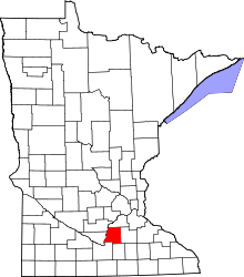 | |
| Townships | ||
| Unincorporated communities | ||
| Footnotes | ‡This populated place also has portions in an adjacent county or counties | |
This article is issued from
Wikipedia.
The text is licensed under Creative Commons - Attribution - Sharealike.
Additional terms may apply for the media files.