Cordova, Minnesota
| Cordova, Minnesota | |
|---|---|
| Unincorporated community | |
 Cordova, Minnesota Location of the community of Cordova within Cordova Township, Le Sueur County  Cordova, Minnesota Cordova, Minnesota (the US) | |
| Coordinates: 44°20′11″N 93°40′18″W / 44.33639°N 93.67167°WCoordinates: 44°20′11″N 93°40′18″W / 44.33639°N 93.67167°W | |
| Country | United States |
| State | Minnesota |
| County | Le Sueur County |
| Township | Cordova Township |
| Elevation | 1,050 ft (320 m) |
| Time zone | UTC-6 (Central (CST)) |
| • Summer (DST) | UTC-5 (CDT) |
| ZIP code | 56057 |
| Area code(s) | 507 |
| GNIS feature ID | 641495[1] |
Cordova is an unincorporated community in Cordova Township, Le Sueur County, Minnesota, United States.
The community is located along Le Sueur County Road 2, near its junction with Le Sueur County Road 5 at Gorman Lake.
County Roads 7 and 11 are also in the immediate area. The Little Cannon River is nearby.
Cordova had a post office from 1857 to 1907. It was platted on September 28, 1867, and incorporated on February 27, 1878, but has since returned to being an unincorporated community within Cordova Township.
Nearby places include Le Center, Waterville, Kilkenny, Montgomery, Lexington, Cleveland, and Elysian.
| Historical population | |||
|---|---|---|---|
| Census | Pop. | %± | |
| 1880 | 140 | — | |
| U.S. Decennial Census[2] | |||
References
Municipalities and communities of Le Sueur County, Minnesota, United States | ||
|---|---|---|
| Cities | 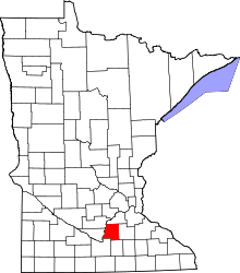 | |
| Townships | ||
| Unincorporated communities | ||
| Footnotes | ‡This populated place also has portions in an adjacent county or counties | |
This article is issued from
Wikipedia.
The text is licensed under Creative Commons - Attribution - Sharealike.
Additional terms may apply for the media files.