Spruce Grove-Stony Plain
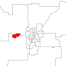 Spruce Grove-Stony Plain within the Edmonton Metropolitan Region (2017 boundaries). | |||
| Provincial electoral district | |||
| Legislature | Legislative Assembly of Alberta | ||
| MLA |
| ||
| District created | 2017 | ||
| First contested | 2019 | ||
| Demographics | |||
| Population (2016)[1] | 51,267 | ||
| Area (km²) | 68.5 | ||
| Pop. density (per km²) | 748.4 | ||
| Census divisions | 11 | ||
| Census subdivisions | Spruce Grove, Stony Plain | ||
Spruce Grove-Stony Plain is a future provincial electoral district in Alberta, Canada. The district will be one of 87 districts mandated to return a single member (MLA) to the Legislative Assembly of Alberta using the first past the post method of voting. It will be contested for the first time in the 2019 Alberta election.
Geography
The district is located west of Edmonton, containing the City of Spruce Grove and the Town of Stony Plain. The district boundaries match the municipal boundaries of the two communities. It is bisected by Highway 16A and bordered by the Yellowhead Highway to the North.
History
| Members for Spruce Grove-Stony Plain | ||||
|---|---|---|---|---|
| Assembly | Years | Member | Party | |
| See Spruce Grove-St. Albert 2012-2019 and Stony Plain 1905-2019 | ||||
| 30th | 2019– | To be determined | ||
The district was created in 2017 when the Electoral Boundaries Commission recommended abolishing Spruce Grove-St. Albert and Stony Plain, creating a district that is well above the provincial average in population. The Commission reasoned this was preferable to placing part of either community in a neighbourhing district.[2]
Electoral results
Elections in the 2010s
| Redistributed results, 2015 Alberta election | ||||
|---|---|---|---|---|
| Party | Votes | % | ||
| New Democratic | 7,738 | 41.74 | ||
| Progressive Conservative | 4,699 | 25.35 | ||
| Wildrose | 4,236 | 22.85 | ||
| Alberta Party | 955 | 5.15 | ||
| Liberal | 683 | 3.68 | ||
| Green | 228 | 1.23 | ||
| Alberta general election, 2019 | ||||||||
|---|---|---|---|---|---|---|---|---|
| Party | Candidate | Votes | % | ±% | ||||
| New Democratic | ||||||||
| United Conservative | ||||||||
| Total valid votes | ||||||||
| Rejected, spoiled and declined | ||||||||
| Registered electors / turnout | ||||||||
References
- ↑ Statistics Canada: 2016
- ↑ "Final Report" (PDF). Alberta Electoral Boundaries Commission. 2017-10-01. p. 57.
 |
Lac Ste. Anne-Parkland |
| |||||
| Drayton Valley-Devon |