Springdale, Utah
| Springdale, Utah | |
|---|---|
| Town | |
 | |
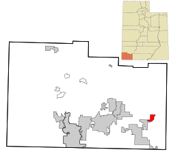 Location in Washington County and the state of Utah | |
| Coordinates: 37°11′4″N 112°59′59″W / 37.18444°N 112.99972°WCoordinates: 37°11′4″N 112°59′59″W / 37.18444°N 112.99972°W | |
| Country | United States |
| State | Utah |
| County | Washington |
| Settled | 1862 |
| Named for | Springs |
| Area | |
| • Total | 4.6 sq mi (12.0 km2) |
| • Land | 4.6 sq mi (12.0 km2) |
| • Water | 0.0 sq mi (0.0 km2) |
| Elevation | 3,898 ft (1,188 m) |
| Population (2012) | |
| • Total | 547 |
| • Density | 115/sq mi (44.1/km2) |
| Time zone | UTC-7 (Mountain (MST)) |
| • Summer (DST) | UTC-6 (MDT) |
| ZIP codes | 84767, 84779 |
| Area code(s) | 435 |
| FIPS code | 49-71840[1] |
| GNIS feature ID | 1432867[2] |
Springdale is a town in Washington County, Utah, United States. The population was 529 at the 2010 census. It is located immediately outside the boundaries of Zion National Park, and is oriented around the resulting tourist industry.[3] It was originally settled as a Mormon farming community in 1862 by evacuees from the flooding of nearby Northrop.[4] Springdale was named one of the 20 'prettiest towns' in the United States by Forbes Traveler in 2008.[5]
Geography

Springdale is located at an elevation of 3,900 feet (1,200 m).
According to the United States Census Bureau, the town has a total area of 4.6 square miles (12.0 km²), all land.
Demographics
| Historical population | |||
|---|---|---|---|
| Census | Pop. | %± | |
| 1880 | 50 | — | |
| 1890 | 73 | 46.0% | |
| 1900 | 144 | 97.3% | |
| 1910 | 186 | 29.2% | |
| 1920 | 204 | 9.7% | |
| 1930 | 351 | 72.1% | |
| 1940 | 454 | 29.3% | |
| 1950 | 174 | −61.7% | |
| 1960 | 248 | 42.5% | |
| 1970 | 182 | −26.6% | |
| 1980 | 258 | 41.8% | |
| 1990 | 275 | 6.6% | |
| 2000 | 457 | 66.2% | |
| 2010 | 529 | 15.8% | |
| Est. 2016 | 570 | [6] | 7.8% |
| U.S. Decennial Census[7] | |||
As of the census[1] of 2010, there were 529 people, 252 households, and 137 families residing in the town. The population density was 115 people per square mile (44.1/km²). There were 327 housing units at an average density of 71.1 per square mile (27.3/km²). The racial makeup of the town was 90.2% White, 0.9% African American, 0.6% Native American, 0.8% Asian, 5.7% from other races, and 1.9% from two or more races. Hispanic or Latino of any race were 11.2% of the population.
There were 252 households out of which 15.1% had children under the age of 18 living with them, 44.0% were married couples living together, 6.7% had a female householder with no husband present, and 45.6% were non-families. 34.2% of all households were made up of individuals and 8.7% had someone living alone who was 65 years of age or older. The average household size was 2.38 and the average family size was 2.67.
In the town, the population was spread out with 15.3% under the age of 18, 4.5% from 20 to 24, 24.2% from 25 to 44, 35.4% from 45 to 64, and 18.9% who were 65 years of age or older. The median age was 47.8 years. For every 100 females, there were 106.6 males. For every 100 women age 18 and over, there were 106.5 men.
As of 2000, the median income for a household in the town was $41,607, and the median income for a family was $51,500. Males had a median income of $34,063 versus $26,667 for females. The per capita income for the town was $25,593. About 8.3% of families and 9.0% of the population were below the poverty line, including 12.0% of those under age 18 and 12.3% of those age 65 or over.
References
- 1 2 "American FactFinder". United States Census Bureau. Retrieved 2008-01-31.
- ↑ "US Board on Geographic Names". United States Geological Survey. 2007-10-25. Retrieved 2008-01-31.
- ↑ Carlisle, Nate (June 12, 2012). "Audit: Small town Utah cops targeted foreign tourists". The Salt Lake Tribune. The Salt Lake Tribune. Retrieved Jan 11, 2013.
- ↑ Webb, R. H.; Blainey, J. B.; Hyndman, D. W. (2002). "Paleoflood Hydrology of the Paria River, Southern Utah and Northern Arizona, USA". In House, P. Kyle. Ancient floods, modern hazards: principles and applications of paleoflood hydrology. 1. American Geophysical Union. p. 297.
- ↑ "Archived copy". Archived from the original on 2008-10-11. Retrieved 2008-10-13.
- ↑ "Population and Housing Unit Estimates". Census.gov. Retrieved June 9, 2017.
- ↑ "Census of Population and Housing". Census.gov. Retrieved June 4, 2015.
External links
| Wikimedia Commons has media related to Springdale, Utah. |
| Wikivoyage has a travel guide for Springdale (Utah). |
- Springdale Town Website
- Z-Arts! Zion Arts and Humanities Council
- Grafton Heritage Project Springdale Area Ghost Town Preservation
- Zion Park Tourism Board
- Washington County School District Springdale Public Schools
Places adjacent to Springdale, Utah | ||||||||||
|---|---|---|---|---|---|---|---|---|---|---|
| ||||||||||
Municipalities and communities of Washington County, Utah, United States | ||
|---|---|---|
| Cities | 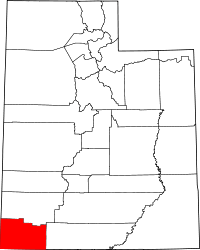 | |
| Towns | ||
| CDPs | ||
| Unincorporated communities | ||
| Ghost towns | ||
| Indian reservation | ||
| Footnotes | ‡This populated place also has portions in an adjacent county or counties | |