Southington Township, Trumbull County, Ohio
| Southington Township, Trumbull County, Ohio | |
|---|---|
| Township | |
 | |
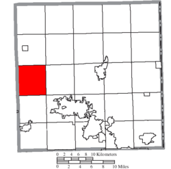 Location of Southington Township in Trumbull County | |
| Coordinates: 41°18′22″N 80°56′48″W / 41.30611°N 80.94667°WCoordinates: 41°18′22″N 80°56′48″W / 41.30611°N 80.94667°W | |
| Country | United States |
| State | Ohio |
| County | Trumbull |
| Area | |
| • Total | 26.0 sq mi (67.3 km2) |
| • Land | 25.9 sq mi (67.2 km2) |
| • Water | 0.0 sq mi (0.1 km2) |
| Elevation[1] | 909 ft (277 m) |
| Population (2000) | |
| • Total | 3,817 |
| • Density | 147.2/sq mi (56.8/km2) |
| Time zone | UTC-5 (Eastern (EST)) |
| • Summer (DST) | UTC-4 (EDT) |
| ZIP code | 44470 |
| Area code(s) | 234/330 |
| FIPS code | 39-73397[2] |
| GNIS feature ID | 1087043[1] |
Southington Township is one of the twenty-four townships of Trumbull County, Ohio, United States. The 2000 census found 3,817 people in the township.[3]
Geography
Located in the western part of the county, it borders the following townships:
- Farmington Township - north
- Bristol Township - northeast corner
- Champion Township - east
- Warren Township - southeast corner
- Braceville Township - south
- Windham Township, Portage County - southwest corner
- Nelson Township, Portage County - west
- Parkman Township, Geauga County - northwest corner
No municipalities are located in Southington Township, although the unincorporated community of Southington lies at the center of the township.
Government
The township is governed by a three-member board of trustees, who are elected in November of odd-numbered years to a four-year term beginning on the following January 1. Two are elected in the year after the presidential election and one is elected in the year before it. There is also an elected township fiscal officer,[4] who serves a four-year term beginning on April 1 of the year after the election, which is held in November of the year before the presidential election. Vacancies in the fiscal officership or on the board of trustees are filled by the remaining trustees.
Public services
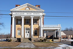
Students in Southington attend Southington Local Schools. It comprises Southington Elementary School, Southington Middle School, and Chalker High School. The elementary, middle, and high schools are all on the same campus.
Important highways in Southington Township include U.S. Route 422 and State Routes 534 and 305.
Notable residents
- Chad Petty, baseball player[5]
- Mike Tyson, boxer[6]
References
- 1 2 "US Board on Geographic Names". United States Geological Survey. 2007-10-25. Retrieved 2008-01-31.
- ↑ "American FactFinder". United States Census Bureau. Retrieved 2008-01-31.
- ↑ Trumbull County, Ohio — Population by Places Estimates Ohio State University, 2007. Accessed 15 May 2007.
- ↑ §503.24, §505.01, and §507.01 of the Ohio Revised Code. Accessed 4/30/2009.
- ↑ Chad Petty Baseball Statistics
- ↑ mm52.com : Mike Tyson pictures, biography
External links
Municipalities and communities of Trumbull County, Ohio, United States | ||
|---|---|---|
| Cities | 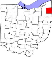 | |
| Villages | ||
| Townships | ||
| CDPs | ||
| Unincorporated communities | ||
| Footnotes | ‡This populated place also has portions in an adjacent county or counties | |