McKinley Heights, Ohio
| McKinley Heights, Ohio | |
|---|---|
| Unincorporated community | |
 McKinley Heights, Ohio  McKinley Heights, Ohio | |
| Coordinates: 41°11′01″N 80°43′02″W / 41.18361°N 80.71722°WCoordinates: 41°11′01″N 80°43′02″W / 41.18361°N 80.71722°W | |
| Country | United States |
| State | Ohio |
| County | Trumbull |
| Area[1] | |
| • Total | 0.871 sq mi (2.26 km2) |
| • Land | 0.871 sq mi (2.26 km2) |
| • Water | 0 sq mi (0 km2) |
| Elevation | 991 ft (302 m) |
| Population (2010)[1] | |
| • Total | 1,060 |
| • Density | 1,200/sq mi (470/km2) |
| Time zone | UTC-5 (Eastern (EST)) |
| • Summer (DST) | UTC-4 (EDT) |
| Area code(s) | 234/330 |
| GNIS feature ID | 1048960[2] |
McKinley Heights is an unincorporated community and census-designated place in Trumbull County, Ohio, United States. Its population was 1,060 as of the 2010 census.[1] The community is located at the intersection of U.S. Route 422 and Ohio State Route 169.
Geography
According to the U.S. Census Bureau, the community has an area of 0.871 square miles (2.26 km2), all of it land.[1]
Demographics
McKinley Heights contains 1060 residents, in which 97% are white/caucasian.[3]. There are 533 male residents and 527 female residents of the town.
References
- 1 2 3 4 "2010 Census Gazetteer Files - Places: Ohio". U.S. Census Bureau. Retrieved February 25, 2017.
- ↑ "McKinley Heights". Geographic Names Information System. United States Geological Survey.
- ↑ "Population Demographics for Mckinley Heights, Ohio in 2017, 2018". Suburban Stats. Suburban Stats. Retrieved 7 August 2018.
Municipalities and communities of Trumbull County, Ohio, United States | ||
|---|---|---|
| Cities | 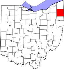 | |
| Villages | ||
| Townships | ||
| CDPs | ||
| Unincorporated communities | ||
| Footnotes | ‡This populated place also has portions in an adjacent county or counties | |
This article is issued from
Wikipedia.
The text is licensed under Creative Commons - Attribution - Sharealike.
Additional terms may apply for the media files.