Morgandale, Ohio
| Morgandale, Ohio | |
|---|---|
| Unincorporated community | |
 Morgandale, Ohio  Morgandale, Ohio | |
| Coordinates: 41°15′56″N 80°46′58″W / 41.26556°N 80.78278°WCoordinates: 41°15′56″N 80°46′58″W / 41.26556°N 80.78278°W | |
| Country | United States |
| State | Ohio |
| County | Trumbull |
| Area[1] | |
| • Total | 2.658 sq mi (6.88 km2) |
| • Land | 2.658 sq mi (6.88 km2) |
| • Water | 0 sq mi (0 km2) |
| Elevation | 925 ft (282 m) |
| Population (2010)[1] | |
| • Total | 1,224 |
| • Density | 460/sq mi (180/km2) |
| Time zone | UTC-5 (Eastern (EST)) |
| • Summer (DST) | UTC-4 (EDT) |
| Area code(s) | 234/330 |
| GNIS feature ID | 2633225[2] |
Morgandale is an unincorporated community and census-designated place in Trumbull County, Ohio, United States. Its population was 1,224 as of the 2010 census.[1]
Geography
According to the U.S. Census Bureau, the community has an area of 2.658 square miles (6.88 km2), all of it land.[1]
References
- 1 2 3 4 "2010 Census Gazetteer Files - Places: Ohio". U.S. Census Bureau. Retrieved February 25, 2017.
- ↑ "Morgandale". Geographic Names Information System. United States Geological Survey.
Municipalities and communities of Trumbull County, Ohio, United States | ||
|---|---|---|
| Cities | 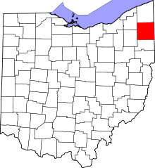 | |
| Villages | ||
| Townships | ||
| CDPs | ||
| Unincorporated communities | ||
| Footnotes | ‡This populated place also has portions in an adjacent county or counties | |
This article is issued from
Wikipedia.
The text is licensed under Creative Commons - Attribution - Sharealike.
Additional terms may apply for the media files.