South Carolina Highway 248
| ||||
|---|---|---|---|---|
| William Bruce Ezell Memorial Highway | ||||
 | ||||
| Route information | ||||
| Maintained by SCDOT | ||||
| Length | 6.17 mi[1] (9.93 km) | |||
| Existed | 1940 – present | |||
| Major junctions | ||||
| South end |
| |||
| North end |
| |||
| Location | ||||
| Counties | Greenwood | |||
| Highway system | ||||
| ||||

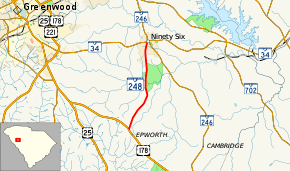
South Carolina Highway 248 (SC 248) is a primary state highway in the U.S. state of South Carolina. It serves as main access to the Ninety Six National Historic Site.
Route description
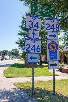
SC 248 is a two-lane rural highway that traverses for 6.2 miles (10.0 km) from Epworth at U.S. Route 178 (US 178) to Ninety Six at SC 34/SC 246.[2]
History
Established in 1940, it is the second SC 248 and has remained unchanged since inception. The first SC 248 was established by 1930 as a renumbering of SC 151 from US 29/SC 24 in Anderson to SC 20 in Williamston. In 1935, SC 248 was renumbered as part of US 29.[3]
Junction list
The entire route is in Greenwood County.
| Location | mi[1] | km | Destinations | Notes | |
|---|---|---|---|---|---|
| Epworth | 0.00 | 0.00 | |||
| Ninety Six | 6.17 | 9.93 | |||
| 1.000 mi = 1.609 km; 1.000 km = 0.621 mi | |||||
References
- 1 2 South Carolina Department of Transportation: Statewide Highways 2012. Specifics: . Files: .
- ↑ Google (September 1, 2013). "South Carolina Highway 248" (Map). Google Maps. Google. Retrieved September 1, 2013.
- ↑ General Highway Map, Greenwood County, South Carolina (PDF) (Map). Cartography by SCDOT. South Carolina Department of Transportation. 1940. Retrieved September 10, 2013.
External links
Route map:

- Mapmikey's South Carolina Highways Page: SC 248
This article is issued from
Wikipedia.
The text is licensed under Creative Commons - Attribution - Sharealike.
Additional terms may apply for the media files.