South Carolina Highway 245
| ||||
|---|---|---|---|---|
 | ||||
| Route information | ||||
| Maintained by SCDOT | ||||
| Length | 5.06 mi[1] (8.14 km) | |||
| Existed | 1931 – present | |||
| Major junctions | ||||
| South end |
| |||
|
| ||||
| North end |
| |||
| Location | ||||
| Counties | Lexington | |||
| Highway system | ||||
| ||||

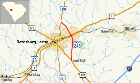
South Carolina Highway 245 (SC 245) is a 5.1-mile-long (8.2 km) highway in the U.S. state of South Carolina. The highway was built and paved in 1932 as a short spur of SC 24 passing north through Leesville to connect with SC 391.[2] Since being built, that section of SC 24 was redesignated as US 178 in 1933, and Leesville merged in 1992 with Batesburg, where US 1 and SC 391 intersect, to form the town of Batesburg-Leesville. It is known locally as North Lee Street north of the railroad tracks, and as South Lee Street south of the railroad tracks. There are two traffic lights along SC 245.[3]
Route description
History
Major intersections
The entire route is in Lexington County.
| Location | mi[3] | km | Destinations | Notes | |
|---|---|---|---|---|---|
| | 0.00 | 0.00 | |||
| Batesburg-Leesville | 2.98 | 4.80 | |||
| 3.10 | 4.99 | ||||
| | 5.06 | 8.14 | |||
| 1.000 mi = 1.609 km; 1.000 km = 0.621 mi | |||||
References
- ↑ "Statewide Highways (shapefile)" (zip). South Carolina Department of Transportation. September 29, 2017. Retrieved December 8, 2017.
- ↑ General Highway System - Lexington County, South Carolina (PDF) (Map). South Carolina Department of Transportation. August 2005. Retrieved February 2, 2013.
- 1 2 Google (February 2, 2013). "South Carolina Highway 245" (Map). Google Maps. Google. Retrieved February 2, 2013.
External links
Route map:
| Wikimedia Commons has media related to South Carolina Highway 245. |
This article is issued from
Wikipedia.
The text is licensed under Creative Commons - Attribution - Sharealike.
Additional terms may apply for the media files.