South Amherst Common Historic District
|
South Amherst Common Historic District | |
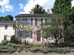 324 Pomeroy Lane | |
  | |
| Location | 445 Shays Street, South Amherst Common, 979—1081 S. East Street and 324 Pomeroy Lane, Amherst, Massachusetts |
|---|---|
| Coordinates | 42°20′29″N 72°30′18″W / 42.34139°N 72.50500°WCoordinates: 42°20′29″N 72°30′18″W / 42.34139°N 72.50500°W |
| Area | 13 acres (5.3 ha) |
| Built | 1788 |
| Architect | Putnam, Karl S.; Gos, Philip L., & George Nutting |
| Architectural style | Georgian, Federal, Mid 19th Century Revival |
| NRHP reference # | [1] |
| Added to NRHP | February 17, 1995 |
The South Amherst Common Historic District encompasses the village common and surrounding buildings of South Amherst, Massachusetts. This area developed as a rural residential village hub in the 18th and 19th centuries. It was listed on the National Register of Historic Places in 1995.[1]
Description and history
The town of Amherst was settled as part of Hadley in the early 18th century, and was separately incorporated in 1759. The South Amherst Common was formed out of a road junction created in 1760 by laying out the southern portion of what is now South East Road, the northern portion and Middle Street having been laid out in 1703. The first house known to be built facing what is now the common was built about 1742 by Nathaniel Coleman, and still stands at 1055 South East Street. In 1788 the town reduced the rights of way for its roads, and sold off the excess land, but keeping the area that is now South Amherst Common. Over the next 150 years, the common became a local nexus for the surrounding rural community, with a school (first one built in 1764) and church (1825), and several cottage industries. Station Road was built extending eastward from the common in 1821, and Pomeroy Lane to its west in 1825. The area has remained rural with increasing suburbanization since then.[2]
The common as seen today consists of a roughly triangular area bounded by South East Road on the east, Middle Road on the west, and Shays Street on the south. This triangular area is further cut by cross roads into a total of five different areas. The common itself is a grassy area unadorned by monuments and dotted with trees. Facing the common are primarily residences of 19th-century wood-frame construction, with a few instances of 18th and 20th-century buildings. Prominent non-residential buildings are the 1825 Classical Revival Congregational church, the 1902 South Amherst School, and the 1930 Munson Memorial Library and Community Center. One brick house stands on Pomeroy Lane, and there are four non-contributing but sympathetically styled 1950s Capes that also face the common.[2]
See also
References
- 1 2 National Park Service (2008-04-15). "National Register Information System". National Register of Historic Places. National Park Service.
- 1 2 "NRHP nomination for South Amherst Common Historic District". National Park Service. Retrieved 2017-07-09.
| Topics |  | ||||||||||||||||
|---|---|---|---|---|---|---|---|---|---|---|---|---|---|---|---|---|---|
| Lists by county | |||||||||||||||||
| Lists by city |
| ||||||||||||||||
| Other lists | |||||||||||||||||
| |||||||||||||||||