Smock Historic District
|
Smock Historic District | |
 | |
  | |
| Location | Roughly bounded by Redstone Cemetery, Colonial Mine No. 1, Smock Hill, Colonial Mine No. 2 and Redstone Cr., Franklin Township and Menallen Township, Pennsylvania |
|---|---|
| Coordinates | 39°59′59″N 79°46′39″W / 39.99972°N 79.77750°WCoordinates: 39°59′59″N 79°46′39″W / 39.99972°N 79.77750°W |
| Area | 187 acres (76 ha) |
| Built | 1911 |
| Built by | Pittsburg Coal Co. et al |
| MPS | Bituminous Coal and Coke Resources of Pennsylvania MPS |
| NRHP reference # | 94000520[1] |
| Added to NRHP | June 3, 1994 |
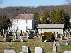
Smock Historic District is a national historic district located at Franklin Township and Menallen Township, Fayette County, Pennsylvania. The district includes 177 contributing buildings, 4 contributing sites, 7 contributing structures, and 1 contributing object in the coal mining community of Smock. Most of the contributing buildings and structures were built between the 1880s and 1923. They include the extractive and archaeological remains of Colonial Mines No. 1 and 2 and related coke operations, 109 company built dwellings (92 workers' houses and 17 managers' houses), the Redstone Creek bridge, and the Smock War Monument. Other buildings include three schools, the company store, three churches, and a movie theater.[2]
It was added to the National Register of Historic Places in 1994.[1]
References
- 1 2 National Park Service (2010-07-09). "National Register Information System". National Register of Historic Places. National Park Service.
- ↑ "National Historic Landmarks & National Register of Historic Places in Pennsylvania" (Searchable database). CRGIS: Cultural Resources Geographic Information System. Note: This includes Carmen DiCiccio (January 1994). "National Register of Historic Places Inventory Nomination Form: Smock Historic District" (PDF). Retrieved 2012-01-29.
External links
- Historic American Engineering Record (HAER) No. PA-365, "Colonial Mines Bathhouse, Smock, Fayette County, PA", 1 photo, 5 data pages, 1 photo caption page
| Topics |   | |
|---|---|---|
| Lists by county |
| |
| Lists by city | ||
| Other lists | ||
| ||