Smila
| Smila Сміла | |||
|---|---|---|---|
| City | |||
| |||
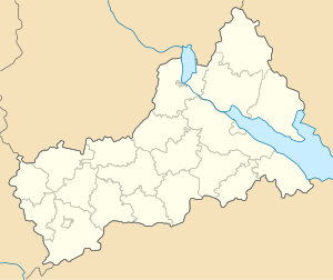 Smila Location of Smila  Smila Smila (Ukraine) | |||
| Coordinates: 49°12′42″N 31°52′23″E / 49.21167°N 31.87306°ECoordinates: 49°12′42″N 31°52′23″E / 49.21167°N 31.87306°E | |||
| Country | Ukraine | ||
| Oblast | Cherkasy | ||
| Municipality | Smila | ||
| Founded | 1542 | ||
| City status | 1926 | ||
| Government | |||
| • Mayor | Viktor Fedorenko | ||
| Area | |||
| • Land | 39.85 km2 (15.39 sq mi) | ||
| Elevation | 101 m (331 ft) | ||
| Population | |||
| • Total | 68,805 | ||
| Time zone | UTC+2 (EET) | ||
| • Summer (DST) | UTC+3 (EEST) | ||
| Postal code | 20700 | ||
| Area code(s) | +380 4733 | ||
| Sister cities | Rzhev, Newton, Iowa, Vatutine, Irpin | ||
| Website | www.smila.ck.ua | ||


Smila (Ukrainian pronunciation: [ˈsmʲiɫɑ]) is a city located on Dnieper Upland near the Tyasmyn River. It is a district center of Cherkasy Oblast of Ukraine. Smila is the biggest transport center of the region as a huge railway station is located here. Settlements Ploske and Irdynivka are subordinated to Smila city council. During the Russian Empire Smila was a township which subordinated to Cherkassy county of Kyiv hubernia.
Smila serves as the administrative center of Smila Raion (district), but is designated as a city of oblast significance and does not belong to the raion. Population: 68,805 (2017 est.)[1]
Climate
Climate in the city is moderate continental. Winters are soft with frequent thaws. Summers are warm, sometimes with little rain. Periods of temperatures higher than +10 endure up to 170 days. Annual precipitation level is 450–520 mm. Dnieper tributary Tyasmyn River flows through the city. .[2]
History
Foundation of Smila
Smila and its neighbourhood have been settled since the ancient times. Archeologists discovered a lot of ruins of ancient settlements and numerous mounds located in different parts of Smila and near the city. Two biggest ancient settlements and 44 mounds were first researched during 1879–1883 years by O. O. Bobrynsky, grandson of Smila owner, Count Olexiy Olexiyovich Bobrynsky. These findings belong partly to the Stone Age and partly to the Bronze age.
Official foundation date of Smila is 1542. Grand Duchy of Lithuania documents tell us that settlement Yatzkove-Tyasmyno was founded on a hamlet place in 1542. The modern name of the city has been known since the first half of the 17th century.
City’s name is connected with a local legend first recorded by Count L. O. Bobrynsky: "An unknown girl led warriors through a heavy swamp showing a route to the enemy. The battle was very bloody. They killed a lot of enemies there but they couldn’t save the brave girl. They buried her near Tyasmyn and called her Smila.[3] Then warriors honoured her in the city’s name."
Cossack Hetmanate
During 1648 — 1667 this squadron town belonged to Chyhyryn Regiment. In 1654 Russian tsar gave Pereyaslav colonel Pavlo Teteria possession of the town. During 1658-1659 Danylo Vyhovsky changed Teterya as the owner. Chudniv treaty of 1660 renewed Polish power on this land. Smila became an ownership of Stanislav Koniecpolski as part of Polish-Lithuanian Commonwealth. Constant wars between Ukrainian Cossacks, Polish owners, Tatars, Turks, Russians and Swedes [4] led to demolition of Smila. (More The Ruin) Further owners of Smila, princes Lubomirski built a wooden castle with arbor and palisade around the whole city in 1742. During 1730s-1760s parts of the population of Smila took part in Haidamaka movement. In 1787 prince Xaveriy Lubomirski sold lands around Smila to Russian prince Potyomkin. Six years later Smila became a property of Potyomkin’s nephew, Count Alexander Samoylov. Two years later population of Smila was 1747 people with 50 crafters, 9 shoemakers, 6 weavers, 8 tailors. Others were peasants.
Economy
The economic emphasis is on mechanical engineering, and the food industry is also of importance.
Smila, where the Kiev–Dnipro and Odessa–Russia rail routes cross, is one of the most important railway junctions in Ukraine. The large station at the junction is named after Ukraine's national poet, Taras Shevchenko.
Gallery
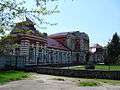 Female gymnasium building
 Assumption Church in Smila
 Church of the Holy Virgin
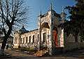 Museum of Local History
 Technical Institute for Sugar Industry in Smila
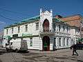 Bank building in Smila
_01.JPG) Shevchenko district
Shevchenko district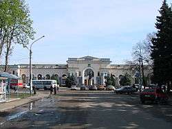 Railway station
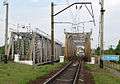 Railway bridge in Smila
 Tiasmyn River in Smila
Sister cities


References
- ↑ "Чисельність наявного населення України (Actual population of Ukraine)" (in Ukrainian). State Statistics Service of Ukraine. Retrieved 26 August 2017.
- ↑ http://www.oldrpz.cherkasy.net/ua/region_text2.htm%5Bpermanent+dead+link%5D
- ↑ It means - brave
- ↑ http://www.pravoslavie.ru/smi/103.htm
- (in Ukrainian) (1972) Історіа міст i сіл Укpaїнcькoї CCP - Черкаськa область (History of Towns and Villages of the Ukrainian SSR - Cherkasy Oblast), Kiev.
External links
- (in Ukrainian) Official city website
- (in Ukrainian) Unofficial city website
| Raions | |||||
|---|---|---|---|---|---|
| Cities |
| ||||
| |||||