Slieve na Calliagh
| Slieve na Calliagh | |
|---|---|
| Sliabh na Caillí | |
 | |
| Highest point | |
| Elevation | 276 m (906 ft) [1] |
| Prominence | 150 m (490 ft) [1] |
| Listing | Marilyn |
| Coordinates | 53°44′40″N 7°06′42″W / 53.74452°N 7.11167°WCoordinates: 53°44′40″N 7°06′42″W / 53.74452°N 7.11167°W |
| Naming | |
| Translation | the hag's mountain (Irish) |
| Geography | |
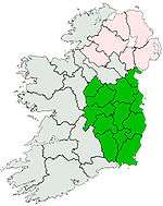
 Slieve na Calliagh Location in Ireland | |
| Location | County Meath, Republic of Ireland |
| Parent range | Meath Hills |
| OSI/OSNI grid | N586775 |
Slieve na Calliagh (Irish: Sliabh na Caillí, meaning "the Cailleach's mountain") is a range of hills and archaeological site near Oldcastle, County Meath, Ireland. The hills rise to 276 metres (906 ft) above sea level, the highest point in the county. On the hilltops are a group of megalithic tombs dating back to the 4th millennium BC. These tombs are also known as Slieve na Calliagh,[2] or as the Loughcrew tombs. The rays of the equinox sunrise shine down the passageway of the Cairn T and illuminate an inner chamber filled with megalithic stonecarvings. It is deemed one of the four main passage tomb sites in Ireland and is a protected National Monument.
Slieve na Calliagh includes the hills of Carnbane West, Carrickbrack, Carnbane East and Patrickstown Hill. The hills are named after the Cailleach, the divine hag of Irish mythology. Legend has it that the monuments were created when a giant hag, striding across the land, dropped her cargo of large stones from her apron.

See also
References
- 1 2 "North Midlands Area - Slieve Na Calliagh Hill". MountainViews. Ordnance Survey Ireland. Retrieved May 21, 2015.
- ↑ Slieve na Calliagh/Sliabh na Caillí. Placenames Database of Ireland.
External links
- Megalithic Cairns at Slieve na Calliagh - photos and videos from Knowth.com