Skyland, Nevada
| Skyland, Nevada | |
|---|---|
| Census-designated place | |
 Skyland Location of Skyland, Nevada | |
| Coordinates: 39°1′20″N 119°56′33″W / 39.02222°N 119.94250°WCoordinates: 39°1′20″N 119°56′33″W / 39.02222°N 119.94250°W | |
| Country | United States |
| State | Nevada |
| Area | |
| • Total | 4.4 sq mi (11.5 km2) |
| • Land | 4.4 sq mi (11.3 km2) |
| • Water | 0.1 sq mi (0.3 km2) |
| Elevation | 6,260 ft (1,910 m) |
| Population (2010) | |
| • Total | 376 |
| • Density | 86/sq mi (33.3/km2) |
| Time zone | UTC-8 (Pacific (PST)) |
| • Summer (DST) | UTC-7 (PDT) |
| Area code(s) | 775 |
| FIPS code | 32-67600 |
Skyland is a census-designated place (CDP) in Douglas County, Nevada, United States. The population was 376 at the 2010 census.[1]
Geography
Skyland is located on the east shore of Lake Tahoe in far western Nevada. U.S. Route 50 is the main road through the CDP, leading south 5 miles (8 km) to the California state line and northeast 20 miles (32 km) to Carson City. Lakeridge is immediately to the north, and Zephyr Cove borders Skyland to the south.
According to the United States Census Bureau, the Skyland CDP has a total area of 4.4 square miles (11.5 km2), of which 4.4 square miles (11.3 km2) is land and 0.12 square miles (0.3 km2), or 2.26%, is water.[1]
References
- 1 2 "Geographic Identifiers: 2010 Demographic Profile Data (G001): Skyland CDP, Nevada". U.S. Census Bureau, American Factfinder. Retrieved January 24, 2013.
Municipalities and communities of Douglas County, Nevada, United States | ||
|---|---|---|
| CDPs | 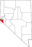 | |
| Unincorporated communities | ||
This article is issued from
Wikipedia.
The text is licensed under Creative Commons - Attribution - Sharealike.
Additional terms may apply for the media files.