Sils im Engadin/Segl
| Sils im Engadin/Segl | ||
|---|---|---|
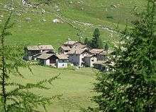
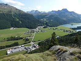 Segl Maria (left) and Segl Baselgia (right) | ||
| ||
 Sils im Engadin/Segl | ||
|
Location of Sils im Engadin/Segl 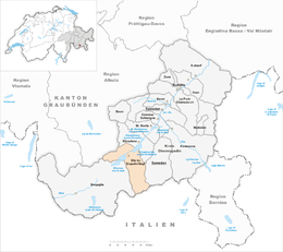 Sils im Engadin/Segl Sils im Engadin/Segl (Canton of Graubünden) | ||
| Coordinates: 46°26′N 9°46′E / 46.433°N 9.767°ECoordinates: 46°26′N 9°46′E / 46.433°N 9.767°E | ||
| Country | Switzerland | |
| Canton | Graubünden | |
| District | Maloja | |
| Area[1] | ||
| • Total | 63.58 km2 (24.55 sq mi) | |
| Elevation (Church Segl Maria) | 1,809 m (5,935 ft) | |
| Population (Dec 2016[2]) | ||
| • Total | 714 | |
| • Density | 11/km2 (29/sq mi) | |
| Postal code | 7514, 7515, 7517 | |
| SFOS number | 3789 | |
| Localities | Segl Maria, Segl Baselgia, Seglias, Val Fex as well as Grevasalvas, Blaunca and Buaira | |
| Surrounded by | Bivio, Chiesa in Valmalenco (IT-SO), Lanzada (IT-SO), Samedan, Silvaplana, Stampa | |
| Website |
www SFSO statistics | |

Sils im Engadin/Segl (German: Sils im Engadin; Romansh ![]()
The municipality consists of two villages Segl Maria (Romansh, German: Sils Maria; Seglias is part of Segl Maria) and Segl Baselgia (German: Sils Baselgia; Baselgia is Romansh for church), the Val Fex (German: Fextal), and the three Maiensässe (Alpine pastures traditionally used for spring grazing) Grevasalvas, Blaunca and Buaira above Plaun da Lej on the left side of the valley.
Name and coat of arms
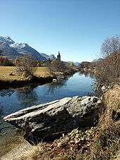
The municipality's official label uses both, the German and the Romansh version of the municipality's name. Segl is the Romansh version while Sils im Engadin is the German. Engadin is Romansh for "Valley of the Inn (Romansh: En)", the river, which flows northeast from Maloja through Sils Baselgia and eventually into the Danube at Passau, Germany at the German-Austrian border.
Sils i.E is distinguished from Sils im Domleschg in another Swiss watershed. Sils was originally divided into the three hamlets of Segl Baselgia and Segl Maria, and Seglias.
The coat of arms is Per fess Azure a Sun radiated Or and Or a Trout Azure spotted Gules.[3] It shows a blue upper half with a golden sun and a yellow lower section with a blue trout. It is a combination of the historical village coats of arms and represents the sunny and elevated location of the municipality and the fish-filled Lake Sils.
History
Sils im Engadin/Segl is first mentioned around 800–850 as Silles. In 1131 it was mentioned as Sillis.[4] Until 1943, Sils im Engadin/Segl was known as Sils im Engadin.[5]
Geography
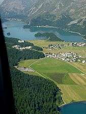
Located in the valley of Upper Engadine, Sils i.E./Segl nestles between Lake Sils and Lake Silvaplana at the foot of Piz Corvatsch and Piz da la Margna and below the Val Fex, a valley in the south. The municipality belongs to the Maloja District.
Sils im Engadin/Segl has an area, (as of the 2004/09 survey) of 63.58 km2 (24.55 sq mi).[1] Of this area, about 25.9% is used for agricultural purposes, while 11.1% is forested. Of the rest of the land, 1.2% is settled (buildings or roads) and 61.7% is unproductive land. In the 2004/09 survey a total of 38 ha (94 acres) or about 0.6% of the total area was covered with buildings, an increase of 5 ha (12 acres) over the 1985 amount. Over the same time period, the amount of recreational space in the municipality increased by 6 ha (15 acres) and is now about 0.16% of the total area. Of the agricultural land, 307 ha (760 acres) is fields and grasslands and 1,435 ha (3,550 acres) consists of alpine grazing areas. Since 1985 the amount of agricultural land has decreased by 119 ha (290 acres). At the same time the amount of forested land has increased by 117 ha (290 acres). Rivers and lakes cover 404 ha (1,000 acres) in the municipality.[6][7]
The plain is cultivated in grass, the steep slopes are heavily forested.
Demographics
Sils im Engadin/Segl has a population (as of December 2016) of 714.[2] As of 2014, 38.5% of the population are resident foreign nationals. In 2015, 144 people or 18.9% of the population were born in Portugal, 42 or 5.5% of the population were born in Germany and 63 or 8.3% of the population were born in Italy.[8] Over the last 4 years (2010-2014) the population has changed at a rate of 2.13%. The birth rate in the municipality, in 2014, was 15.7, while the death rate was 1.3 per thousand residents.[7]
As of 2014, children and teenagers (0–19 years old) make up 17.3% of the population, while adults (20–64 years old) are 65.9% and seniors (over 64 years old) make up 16.8%.[7] In 2015 there were 299 single residents, 381 people who were married or in a civil partnership, 37 widows or widowers and 44 divorced residents.[9]
In 2014 there were 401 private households in Sils im Engadin/Segl with an average household size of 1.91 persons. Of the 253 inhabited buildings in the municipality, in 2000, about 34.8% were single family homes and 36.0% were multiple family buildings. Additionally, about 32.0% of the buildings were built before 1919, while 7.5% were built between 1991 and 2000.[10] In 2013 the rate of construction of new housing units per 1000 residents was 26.46. The vacancy rate for the municipality, in 2015, was 1.2%.[7]
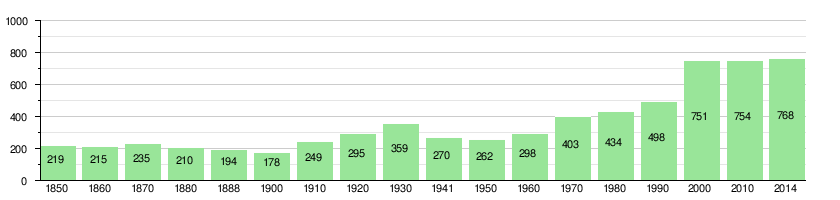
The historical population is given in the following chart:[11]
Languages
Most of the population (as of 2000) speaks German (59.4%), with Italian being second most common (15.4%) and Romansh being third (12.0%).[12] Into the 19th century, the entire population spoke the Upper-Engadin Romansh dialect of Putèr. Due to increasing trade with the outside world, Romansh usage began to decline. In 1880 about 68% spoke Romansh as a first language, while in 1910 it was only 56% and in 1941 it increased to 61.5%. In the 1960s German became the majority language. However, in 2000 there were 33% of the population who at least understood Romansh.
| Languages in Sils im Engadin/Segl | ||||||
| Languages | Census 1980 | Census 1990 | Census 2000 | |||
| Number | Percent | Number | Percent | Number | Percent | |
| German | 210 | 48.39% | 291 | 58.43% | 446 | 59.39% |
| Romansh | 137 | 31.57% | 122 | 24.50% | 90 | 11.98% |
| Italian | 67 | 15.44% | 71 | 14.26% | 116 | 15.45% |
| Population | 434 | 100% | 498 | 100% | 751 | 100% |
Politics
In the 2015 federal election the most popular party was the FDP with 28.5% of the vote. The next three most popular parties were the BDP (24.0%), the SVP (18.5%) and the SP (16.9%). In the federal election, a total of 169 votes were cast, and the voter turnout was 40.6%.[13]
In the 2007, federal election the most popular party was the SVP which received 34.6% of the vote. The next three most popular parties were the SP (29.3%), the FDP (26.6%) and the CVP (7.2%).[12]
Education
In Sils im Engadin/Segl, about 70.6% of the population (between age 25-64) have completed either non-mandatory upper secondary education or additional higher education (either university or a Fachhochschule).[12]
Economy
Sils im Engadin/Segl is classed as a tourist community.[14]
As of 2014, there were a total of 955 people employed in the municipality. Of these, a total of 24 people worked in 8 businesses in the primary economic sector. The secondary sector employed 132 workers in 18 separate businesses, of which 5 were small businesses with a total of 94 employees. Finally, the tertiary sector provided 799 jobs in 85 businesses. There were 14 small businesses with a total of 338 employees and two mid sized businesses with a total of 201 employees.[15] In 2014 a total of 26.5% of the population received social assistance.[7]
In the second quarter of 2016 an average of 251 workers commuted from outside Switzerland to work in the municipality, representing a large minority of the employees.[16]
In 2015 local hotels had a total of 196,257 overnight stays, of which 37.6% were international visitors.[17]
Transportation
The Fex Valley is officially car-free except for residents of the valley. The Furtschellas cable car begins near the village and leads to many ski runs and, in summer, to trails above the tree line.
Climate
Sils-Segl Maria features a cold subarctic climate (Dfc) on Köppen classification.
| Climate data for Segl-Maria (1981-2010) | |||||||||||||
|---|---|---|---|---|---|---|---|---|---|---|---|---|---|
| Month | Jan | Feb | Mar | Apr | May | Jun | Jul | Aug | Sep | Oct | Nov | Dec | Year |
| Average high °C (°F) | −0.1 (31.8) |
1.0 (33.8) |
3.6 (38.5) |
5.8 (42.4) |
10.8 (51.4) |
14.6 (58.3) |
17.5 (63.5) |
17.0 (62.6) |
13.4 (56.1) |
9.5 (49.1) |
4.0 (39.2) |
0.4 (32.7) |
8.1 (46.6) |
| Daily mean °C (°F) | −6.8 (19.8) |
−6.5 (20.3) |
−2.9 (26.8) |
0.7 (33.3) |
5.6 (42.1) |
9.1 (48.4) |
11.5 (52.7) |
11.2 (52.2) |
8.0 (46.4) |
4.0 (39.2) |
−1.4 (29.5) |
−4.9 (23.2) |
2.3 (36.1) |
| Average low °C (°F) | −12.4 (9.7) |
−12.7 (9.1) |
−8.4 (16.9) |
−3.7 (25.3) |
1.2 (34.2) |
4.2 (39.6) |
6.6 (43.9) |
6.4 (43.5) |
3.4 (38.1) |
−0.3 (31.5) |
−5.4 (22.3) |
−9.3 (15.3) |
−2.5 (27.5) |
| Average precipitation mm (inches) | 48 (1.89) |
36 (1.42) |
51 (2.01) |
70 (2.76) |
105 (4.13) |
114 (4.49) |
114 (4.49) |
124 (4.88) |
101 (3.98) |
95 (3.74) |
92 (3.62) |
61 (2.4) |
1,011 (39.8) |
| Average snowfall cm (inches) | 57 (22.4) |
43.8 (17.24) |
56.5 (22.24) |
50.9 (20.04) |
17.1 (6.73) |
1.8 (0.71) |
0.2 (0.08) |
0.3 (0.12) |
2.7 (1.06) |
13.3 (5.24) |
51.9 (20.43) |
58 (22.8) |
353.5 (139.17) |
| Average precipitation days (≥ 1.0 mm) | 6.6 | 5.6 | 6.5 | 8.9 | 11.3 | 11.1 | 10.9 | 11.1 | 8.3 | 8.7 | 8.5 | 8.0 | 105.5 |
| Average snowy days (≥ 1.0 cm) | 7.6 | 6.7 | 7.3 | 7.1 | 2.2 | 0.4 | 0 | 0.1 | 0.4 | 1.8 | 6.6 | 7.4 | 47.6 |
| Average relative humidity (%) | 78.2 | 77.1 | 77.0 | 76.7 | 76.6 | 73.3 | 71.9 | 76.6 | 77.9 | 78.0 | 79.1 | 79.4 | 76.8 |
| Source: MeteoSwiss [18] | |||||||||||||
Notable residents and visitors
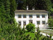
Philosopher Friedrich Nietzsche summered in Sils in 1881 and between 1883 and 1888, and the house he lived in – the Nietzsche-Haus – is now a small museum. Anne Frank was in Sils for several vacations, and Hermann Hesse also visited Sils. Annemarie Schwarzenbach lived in Sils since 1935 and died there in 1942 after a bicycle accident.
In popular culture
The area is the setting for much of the 2014 film Clouds of Sils Maria, written and directed by Olivier Assayas, and starring Juliette Binoche, Kristen Stewart, and Chloë Grace Moretz.
References
- 1 2 Arealstatistik Standard - Gemeindedaten nach 4 Hauptbereichen
- 1 2 Swiss Federal Statistical Office - STAT-TAB, online database – Ständige und nichtständige Wohnbevölkerung nach institutionellen Gliederungen, Geburtsort und Staatsangehörigkeit (in German) accessed 30 August 2017
- ↑ "Sils im Engadin/Segl commune (Graubünden/Grischun canton, Switzerland)". Flagspot.net. Retrieved 2017-03-05.
- ↑ Sils im Engadin/Segl in German, French and Italian in the online Historical Dictionary of Switzerland.
- ↑ "Amtliches Gemeindeverzeichnis der Schweiz". Bfs.admin.ch. Retrieved 2017-03-05.
- ↑ "Arealstatistik Land Use - Gemeinden nach 10 Klassen". http://www.landuse-stat.admin.ch. Swiss Federal Statistical Office. 24 November 2016. Retrieved 27 December 2016. External link in
|website=(help) - 1 2 3 4 5 Swiss Federal Statistical Office - Regional portraits accessed 27 October 2016
- ↑ Federal Statistical Office - Ständige und nichtständige Wohnbevölkerung nach institutionellen Gliederungen, Geburtsort und Staatsangehörigkeit (Land) accessed 31 October 2016
- ↑ Swiss Federal Statistical Office - Ständige und nichtständige Wohnbevölkerung nach institutionellen Gliederungen, Geschlecht, Zivilstand und Geburtsort (in German) accessed 8 September 2016
- ↑ Swiss Federal Statistical Office STAT-TAB - Thema 09 - Bau- und Wohnungswesen (in German) accessed 5 May 2016
- ↑ Swiss Federal Statistical Office STAT-TAB Bevölkerungsentwicklung nach institutionellen Gliederungen, 1850-2000 (in German) accessed 27 April 2016
- 1 2 3 "Regional statistics". Bfs.admin.ch. Retrieved 2017-03-05.
- ↑ Swiss Federal Statistical Office - Nationalratswahlen 2015: Stärke der Parteien und Wahlbeteiligung nach Gemeinden Archived 2 August 2016 at the Wayback Machine. (in German) accessed 18 July 2016
- ↑ "Die Raumgliederungen der Schweiz 2016" (in German, French, Italian, and English). Neuchâtel, Switzerland: Swiss Federal Statistical Office. 17 February 2016. Retrieved 14 December 2016.
- ↑ Federal Statistical Office -Arbeitsstätten und Beschäftigte nach Gemeinde, Wirtschaftssektor und Grössenklasse accessed 31 October 2016
- ↑ Swiss Federal Statistical Office - Cross Border Workers accessed 27 October 2016
- ↑ Federal Statistical Office - Hotellerie: Ankünfte und Logiernächte der geöffneten Betriebe accessed 31 October 2016
- ↑ "Climate Norm Value Tables". Climate diagrams and normals from Swiss measuring stations. Federal Office of Meteorology and Climatology (MeteoSwiss). Archived from the original on 14 May 2013. Retrieved 23 January 2013. The weather station elevation is 1798 meters above sea level.
External links
| Wikimedia Commons has media related to Sils im Engadin/Segl. |
- Official website of the tourist office
- Official website of the municipality
- Website for the Corvatsch-Furtschellas lift system (in German)
- Sils im Engadin/Segl in German, French and Italian in the online Historical Dictionary of Switzerland.