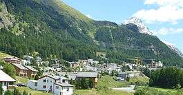
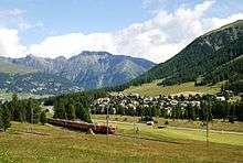
Pontresina
| Pontresina | ||
|---|---|---|
 | ||
| ||
 Pontresina | ||
|
Location of Pontresina 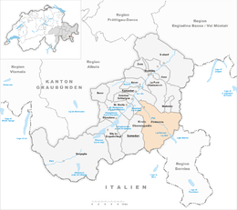 Pontresina Pontresina (Canton of Graubünden) | ||
| Coordinates: 46°30′N 9°54′E / 46.500°N 9.900°ECoordinates: 46°30′N 9°54′E / 46.500°N 9.900°E | ||
| Country | Switzerland | |
| Canton | Graubünden | |
| District | Maloja | |
| Area[1] | ||
| • Total | 118.2 km2 (45.6 sq mi) | |
| Elevation | 1,805 m (5,922 ft) | |
| Population (Dec 2016[2]) | ||
| • Total | 2,197 | |
| • Density | 19/km2 (48/sq mi) | |
| Postal code | 7504 | |
| SFOS number | 3784 | |
| Surrounded by | Lanzada (IT-SO), La Punt-Chamues-ch, Livigno (IT-SO), Madulain, Poschiavo, Samedan, Zuoz | |
| Website |
www SFSO statistics | |

Pontresina (Romansh: Puntraschigna) is a municipality in the Maloja Region in the canton of Graubünden in Switzerland.
History and name
The city was first mentioned in medieval Latin documents as pontem sarasinam in 1137. In 1237 it was mentioned as de Ponte Sarraceno and in 1303 as ponte sarracino.[3] Some historians translate it as The Bridge of the Saracens and see in it a reference to a tenth-century Arab invasion of the lands that later became Switzerland. It is essential though to have a bridge to use the Bernina pass and it would make sense to build this before the confluence of Ova da Bernina and Ova da Roseg due to the amount of water to cross.
Geography
Pontresina has an area, as of 2006, of 118.2 km2 (45.6 sq mi). Of this area, 16.7% is used for agricultural purposes, while 8.8% is forested. Of the rest of the land, 1.6% is settled (buildings or roads) and the remainder (72.9%) is non-productive (rivers, glaciers or mountains).[4]
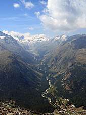
Before 2017, the municipality was located in the Oberengadin sub-district of the Maloja district, after 2017 it was part of the Maloja Region.[5] It sits in Val Bernina, which is the highest altitude valley that branches off the Upper Engadin Valley. The municipality includes the highest mountain of the canton, Piz Bernina. Other high summits are Piz Zupò and Piz Palü. Pontresina is a noted tourist destination in its own right, but is often overshadowed by its more famous neighbor St. Moritz.
It consists of the old village sections of Laret, San Spiert as well as Giarsun and the new sections on the mountain slopes (including Muragls).
Nearby glaciers include the Morteratsch Glacier and the Roseg Glacier. The Morteratsch has a ski lift and a long run down the glacier and the glacier is an economic mainstay of the town.[6] The Roseg Valley has a groomed cross country ski trail along its length.
Demographics
Pontresina has a population (as of 31 December 2016) of 2,197.[2] As of 2008, 29.7% of the population was made up of foreign nationals.[7] Over the last 10 years the population has grown at a rate of 3.9%.[4]
As of 2000, the gender distribution of the population was 50.2% male and 49.8% female.[8] The age distribution, as of 2000, in Pontresina is; 165 children or 7.5% of the population are between 0 and 9 years old. 95 teenagers or 4.3% are 10 to 14, and 136 teenagers or 6.2% are 15 to 19. Of the adult population, 438 people or 20.0% of the population are between 20 and 29 years old. 435 people or 19.9% are 30 to 39, 354 people or 16.2% are 40 to 49, and 269 people or 12.3% are 50 to 59. The senior population distribution is 153 people or 7.0% of the population are between 60 and 69 years old, 97 people or 4.4% are 70 to 79, there are 45 people or 2.1% who are 80 to 89, and there are 4 people or 0.2% who are 90 to 99.[7]
In the 2007 federal election the most popular party was the FDP which received 35.2% of the vote. The next three most popular parties were the SVP (34.1%), the SP (17%) and the CVP (8.1%).[4]
In Pontresina about 62.6% of the population (between age 25-64) have completed either non-mandatory upper secondary education or additional higher education (either university or a Fachhochschule).[4]
Pontresina has an unemployment rate of 1.26%. As of 2005, there were 19 people employed in the primary economic sector and about 4 businesses involved in this sector. 323 people are employed in the secondary sector and there are 22 businesses in this sector. 1,073 people are employed in the tertiary sector, with 124 businesses in this sector.[4]
From the 2000 census, 1,055 or 48.2% are Roman Catholic, while 713 or 32.5% belonged to the Swiss Reformed Church. Of the rest of the population, there are 40 individuals (or about 1.83% of the population) who belong to the Orthodox Church, and there are 56 individuals (or about 2.56% of the population) who belong to another Christian church. There are less than 5 individuals who are Jewish, and 27 (or about 1.23% of the population) who are Islamic. There are 10 individuals (or about 0.46% of the population) who belong to another church (not listed on the census), 158 (or about 7.21% of the population) belong to no church, are agnostic or atheist, and 132 individuals (or about 6.02% of the population) did not answer the question.[7]
The historical population is given in the following table:[3][8]
| year | population |
|---|---|
| 1850 | 270 |
| 1900 | 488 |
| 1950 | 774 |
| 1960 | 1,067 |
| 1970 | 1,646 |
| 1980 | 1,726 |
| 1990 | 1,604 |
| 2000 | 2,191 |
Languages
Most of the population (as of 2000) speaks German (57.7%), with Italian being second most common (16.1%) and Portuguese being third ( 9.0%).[4] Until the 19th Century, the entire population spoke the Upper-Engadin Romansh dialect of Putèr. Due to increasing trade with the outside world, Romansh usage began to decline. In 1880, still 45.7% of the population spoke Romansh as a first language, decreasing to only 33.61% in 1900. The Romansh language continues to decline without an interruption (1941 26.7%, 1970 16.22%, 2000 7.94%).
| Languages in Pontresina GR | ||||||
| Languages | Census 1980 | Census 1990 | Census 2000 | |||
| Number | Percent | Number | Percent | Number | Percent | |
| German | 990 | 57.36% | 993 | 61.91% | 1264 | 57.69% |
| Romansh | 250 | 14.48% | 194 | 12.09% | 174 | 7.94% |
| Italian | 362 | 20.97% | 290 | 18.08% | 353 | 16.11% |
| Population | 1726 | 100% | 1604 | 100% | 2191 | 100% |
Transportation
Pontresina railway station is a fair sized facility positioned to the west of the town which serves a wide area and a youth hostel. Several bus lines of the Engadin Bus company also serve the area and there is a chair lift for skiing in the winter months, and walking in the summer months. The area has road links to the neighbouring, larger town of St Moritz.
Weather
Pontresina has an average of 97.8 days of rain per year and on average receives 799 mm (31.5 in) of precipitation. The wettest month is August during which time Pontresina receives an average of 104 mm (4.1 in) of precipitation. During this month there is precipitation for an average of 10.7 days. The driest month of the year is February with an average of 31 mm (1.2 in) of precipitation over 10.7 days.[9]
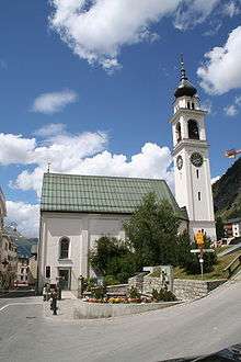
Heritage sites of national significance
The Church of S. Maria, Grand Hotel Kronenhof and the Spaniola tower are listed as Swiss heritage sites of national significance.[10] The old parish church and currently a village church of S. Maria is a late-Romanesque structure. The church has several significant paintings on the walls. The tower and north and west walls are from an earlier church, most likely from the 12th Century.
A historical transport route of wine across the alps passes Pontresina and continues towards Davos across Scaletta Pass that lost importance completely when roads were built elsewhere.[11]
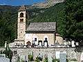 Church of Santa Maria
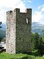 Spaniola Tower
References
- ↑ Arealstatistik Standard - Gemeindedaten nach 4 Hauptbereichen
- 1 2 Swiss Federal Statistical Office - STAT-TAB, online database – Ständige und nichtständige Wohnbevölkerung nach institutionellen Gliederungen, Geburtsort und Staatsangehörigkeit (in German) accessed 30 August 2017
- 1 2 Pontresina in German, French and Italian in the online Historical Dictionary of Switzerland.
- 1 2 3 4 5 6 Swiss Federal Statistical Office accessed 20-Oct-2009
- ↑ Swiss Federal Statistical Office - Amtliches Gemeindeverzeichnis der Schweiz - Mutationsmeldungen 2016 accessed 16 February 2017
- ↑ den Hond, Bas (4 August 2017). "Artificial Snow Could Make Alpine Glacier Grow Again". Eos. Retrieved 12 August 2017.
- 1 2 3 Graubunden Population Statistics Archived 2009-08-27 at the Wayback Machine. (in German) accessed 21 September 2009
- 1 2 Graubunden in Numbers Archived 2009-09-24 at the Wayback Machine. (in German) accessed 21 September 2009
- ↑ "Temperature and Precipitation Average Values-Table, 1961-1990" (in German, French, and Italian). Federal Office of Meteorology and Climatology - MeteoSwiss. Archived from the original on 27 June 2009. Retrieved 8 May 2009. , the weather station elevation is 1774 meters above sea level.
- ↑ Swiss inventory of cultural property of national and regional significance Archived 2009-05-01 at the Wayback Machine. 21.11.2008 version, (in German) accessed 20-Oct-2009
- ↑ (in English) Hiking Switzerland passes in Graubünden on old international trading route
External links
![]()
- Pontresina Web site
- English language website
- Pontresina in German, French and Italian in the online Historical Dictionary of Switzerland.
- Pictures from Pontresina, Switzerland