Sharon, Jones County, Mississippi
| Sharon, Jones County, Mississippi | |
|---|---|
| Census-designated place | |
 Sharon  Sharon | |
| Coordinates: 31°47′22″N 89°5′54″W / 31.78944°N 89.09833°WCoordinates: 31°47′22″N 89°5′54″W / 31.78944°N 89.09833°W | |
| Country | United States |
| State | Mississippi |
| County | Jones |
| Area | |
| • Total | 8.57 sq mi (22.19 km2) |
| • Land | 8.55 sq mi (22.15 km2) |
| • Water | 0.02 sq mi (0.04 km2) |
| Elevation | 315 ft (96 m) |
| Population (2010) | |
| • Total | 1,406 |
| • Density | 164/sq mi (63.5/km2) |
| Time zone | UTC-6 (Central (CST)) |
| • Summer (DST) | UTC-5 (CDT) |
| Area code(s) | 601 |
| FIPS code | 28-66840 |
| GNIS feature ID | 0677615 |
Sharon is an unincorporated community and census-designated place (CDP) in Jones County, Mississippi, United States. The population was 1,406 at the 2010 census.[1] It is part of the Laurel micropolitan statistical area.
Geography
Sharon is in northeastern Jones County and is bordered to the north by Jasper County. It is 7 miles (11 km) north of Laurel, the largest city in Jones County.
According to the United States Census Bureau, the Sharon CDP has a total area of 8.6 square miles (22.2 km2), of which 0.02 square miles (0.04 km2), or 0.20%, are water.[1]
References
- 1 2 "Geographic Identifiers: 2010 Census Summary File 1 (G001): Sharon CDP, Mississippi". American Factfinder. U.S. Census Bureau. Retrieved August 14, 2018.
Municipalities and communities of Jones County, Mississippi, United States | ||
|---|---|---|
| Cities | 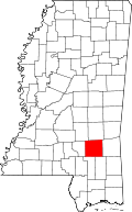 | |
| Towns | ||
| CDP | ||
| Other unincorporated communities | ||
| Indian reservation | ||
| Footnotes | ‡This populated place also has portions in an adjacent county or counties | |
This article is issued from
Wikipedia.
The text is licensed under Creative Commons - Attribution - Sharealike.
Additional terms may apply for the media files.