Ellisville, Mississippi
| Ellisville, Mississippi | |
|---|---|
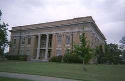 Jones County courthouse in Ellisville | |
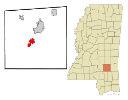 Location of Ellisville in Mississippi | |
 Ellisville, Mississippi Location in the United States | |
| Coordinates: 31°36′4″N 89°12′8″W / 31.60111°N 89.20222°WCoordinates: 31°36′4″N 89°12′8″W / 31.60111°N 89.20222°W | |
| List of countries | United States |
| State | Mississippi |
| County | Jones |
| Government | |
| • Type | City |
| • Mayor | Tim Waldrup |
| Area | |
| • Total | 10.63 sq mi (27.54 km2) |
| • Land | 10.53 sq mi (27.26 km2) |
| • Water | 0.11 sq mi (0.28 km2) |
| Elevation | 253 ft (77 m) |
| Population (2010) | |
| • Total | 4,448 |
| • Estimate (2016)[1] | 4,567 |
| • Density | 423/sq mi (163.2/km2) |
| Time zone | UTC-6 (Central (CST)) |
| • Summer (DST) | UTC-5 (CDT) |
| ZIP code | 39437 |
| Area code(s) | 601 |
| FIPS code | 28-22020 |
| GNIS feature ID | 0669746 |
| Website |
cityofellisvillems |
Ellisville is a city in and the first county seat of Jones County, Mississippi, United States. The population was 4,448 at the time of the 2010 census,[2] up from 3,465 at the 2000 census. The Jones County Courthouse is located here, as is much of the county government.
The state legislature authorized a second county seat at Laurel, to the northeast, which developed as the center of lumber and textile mills, with a much larger population. Ellisville is part of the Laurel micropolitan statistical area.
History
The city is named for Powhatan Ellis,[3] a former U.S. senator for Mississippi who identified as a descendant of Pocahontas and her father, Chief Powhatan in Virginia. Ellisville was designated as the county seat, and it became the major commercial and population center of Jones County through the early decades of development in the nineteenth century.
During the Civil War, Ellisville and Jones County were a center of pro-Union resistance. The county had mostly yeomen farmers and cattle herders, who were not slaveholders. Slaves constituted 12% of the county's population in 1860, the lowest proportion of slaves of any county in the state in 1860, as conditions generally did not support cultivation of large cotton plantations. Many local men resented going to war to support slaveholders, and worried about the survival of their families, where women and children worked to keep subsistence farms going. They resented Confederate tax collectors who took the goods and stores their families needed to live.
Confederate deserters and refugee slaves formed a resistance group known as the Knight Company, led by Newton Knight (self-appointed captain), First Lieutenant Jasper Collins, and Second Lieutenant William Wesley Sumrall. They were known to take refuge in a swamp along the Leaf River. Along with as many as 100 other southern men, they fought several skirmishes with tax men and other Confederate units eventually sent to crush the resistance. In 1864 they took control in Ellisville, raising the United States flag over the courthouse in place of the Confederate flag.
In the late 19th and early 20th centuries, Ellisville lost primacy to nearby Laurel, which became a center of the timber industry and cotton textile mills. Its population in the mid-20th century was nearly six times that of Ellisville. Laurel has attracted other industries and is the center of a micropolitan statistical area comprising all of Jones County and Jasper County. The Jones County Sheriff's Department is based in Laurel, but the county government is still based in Ellisville, at the Jones County Courthouse.
Ellisville reflects the demographics of the county and is majority white. Laurel is majority African American in population, reflecting the migration of agricultural workers to the city for industrial and urban jobs.
Geography
Ellisville is located in central Jones County at 31°36′4″N 89°12′8″W / 31.60111°N 89.20222°W (31.601068, −89.202123).[4] U.S. Route 11 runs through the center of town, while Interstate 59 runs through the northwest side, with access from Exits 85, 88, and 90. Both highways lead northeast 8 miles (13 km) to Laurel and southwest 22 miles (35 km) to Hattiesburg. Mississippi Highway 29 crosses US-11 near the center of town, leading northwest 12 miles (19 km) to Soso and southeast 20 miles (32 km) to Runnelstown.
According to the United States Census Bureau, Ellisville has a total area of 10.6 square miles (27.5 km2), of which 0.12 square miles (0.3 km2), or 1.01%, are water.[2]
Demographics
| Historical population | |||
|---|---|---|---|
| Census | Pop. | %± | |
| 1880 | 37 | — | |
| 1890 | 967 | 2,513.5% | |
| 1900 | 1,899 | 96.4% | |
| 1910 | 2,446 | 28.8% | |
| 1920 | 1,681 | −31.3% | |
| 1930 | 2,127 | 26.5% | |
| 1940 | 2,607 | 22.6% | |
| 1950 | 3,579 | 37.3% | |
| 1960 | 4,592 | 28.3% | |
| 1970 | 4,643 | 1.1% | |
| 1980 | 4,652 | 0.2% | |
| 1990 | 3,634 | −21.9% | |
| 2000 | 3,465 | −4.7% | |
| 2010 | 4,448 | 28.4% | |
| Est. 2016 | 4,567 | [1] | 2.7% |
| U.S. Decennial Census[5] | |||
As of the census[6] of 2000, there were 3,465 people, 1,220 households, and 795 families residing in the city. The population density was 628.9 people per square mile (242.8/km²). There were 1,380 housing units at an average density of 250.5 per square mile (96.7/km²). The racial makeup of the city was 67.42% White, 30.91% African American, 0.20% Native American, 0.17% Asian, 0.61% from other races, and 0.69% from two or more races. Hispanic or Latino of any race were 1.47% of the population.
There were 1,220 households out of which 27.0% had children under the age of 18 living with them, 42.0% were married couples living together, 19.0% had a female householder with no husband present, and 34.8% were non-families. 31.3% of all households were made up of individuals and 13.4% had someone living alone who was 65 years of age or older. The average household size was 2.41 and the average family size was 3.02.
In the city, the population was spread out with 22.4% under the age of 18, 10.2% from 18 to 24, 27.6% from 25 to 44, 22.5% from 45 to 64, and 17.3% who were 65 years of age or older. The median age was 39 years. For every 100 females, there were 92.3 males. For every 100 females age 18 and over, there were 85.3 males.The median income for a household in the city was $23,424, and the median income for a family was $27,955. Males had a median income of $26,477 versus $22,537 for females. The per capita income for the city was $12,822. About 21.1% of families and 35.0% of the population were below the poverty line, including 36.8% of those under age 18 and 28.5% of those age 65 or over.
Education

Ellisville is served by the Jones County School District. South Jones High School is located in Ellisville. Their mascot is the Braves.
Ellisville is also home to Jones County Junior College. Their mascot is the Bobcats.
Notable people
- Lance Bass, pop singer and member of 'N Sync, raised in Ellisville
- Billy Cannon, All-American football player, 1959 Heisman Trophy winner, and 2008 inductee into the College Football Hall of Fame from Louisiana State University in Baton Rouge. He was one of the American Football League's most celebrated players. Attended Jones County Junior College in Ellisville.
- Harry Craft, MLB player and manager, first manager of the Houston Colt .45s and minor league manager of Mickey Mantle
- Chris McDaniel, State Senator, attorney and host of the nationally syndicated The Right Side Radio Show
- Luke McDaniel, also recorded under the stage name 'Jeff Daniels;' American country singer and songwriter
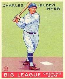
- Buddy Myer, two-time All-Star second baseman for the MLB Washington Senators in the 1930s, batting and stolen base titles
- Red West, actor (played "Red" in Roadhouse). He played football at Jones County Junior College in Ellisville.
See also
References
- 1 2 "Population and Housing Unit Estimates". Retrieved June 9, 2017.
- 1 2 "Geographic Identifiers: 2010 Census Summary File 1 (G001): Ellisville city, Mississippi". American Factfinder. U.S. Census Bureau. Retrieved August 14, 2018.
- ↑ Gannett, Henry (1905). The Origin of Certain Place Names in the United States. Govt. Print. Off. p. 117.
- ↑ "US Gazetteer files: 2010, 2000, and 1990". United States Census Bureau. 2011-02-12. Retrieved 2011-04-23.
- ↑ "Census of Population and Housing". Census.gov. Archived from the original on May 12, 2015. Retrieved June 4, 2015.
- ↑ "American FactFinder". United States Census Bureau. Archived from the original on 2013-09-11. Retrieved 2008-01-31.
External links
- City of Ellisville official website
- Ellisville at City-data.com
Municipalities and communities of Jones County, Mississippi, United States | ||
|---|---|---|
| Cities | 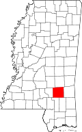 | |
| Towns | ||
| CDP | ||
| Other unincorporated communities | ||
| Indian reservation | ||
| Footnotes | ‡This populated place also has portions in an adjacent county or counties | |