Shangla District
| Shangla District شانگله | |
|---|---|
| District | |
| ضلع شانگله | |
 | |
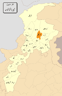 Location of Shangla district in the province of Khyber Pakhtunkhwa | |
| Country | Pakistan |
| Province | Khyber Pakhtunkhwa |
| Headquarters | Alpuri |
| Area | |
| • Total | 1,586 km2 (612 sq mi) |
| Population (2017)[1] | |
| • Total | 757,810 |
| • Density | 480/km2 (1,200/sq mi) |
| Time zone | UTC+5 (PST) |
| District Council | 28 seats |
Shangla District is located in the Khyber-Pakhtunkhwa province of Pakistan.
The district headquarters are located at Alpuri.[2] It was previously a subdivision of Swat District, but was upgraded to the status of a district on July 10, 1995.[3] The total area of the district is 1,586 square kilometres.[3] Shangla comprises three subdivisions, Alpuri, Puran and Besham tehsils.
Shangla has the lowest Human Development Index in the province and second lowest in the country.[4][5]
Location
The district is bounded in the north by Kohistan District, in the east by Battagram District and the tribal area of Kala Dhaka (Black Mountain of Hazara), in the west by Swat District and in the south by Buner District.[3]
History
There are relics of the ancient Greek period at Pirsar, Chakesar and Daut. it is believed that Alexander the Great camped at Pirsar for a few days. There are also relics of the Hindu Shahi in Olandar-Ajmair.[6]
Geography
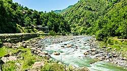
Shangla district consists of small valleys, and is situated between the hillocks and surrounded by high mountains full of forests comprising Pindrow Fir, Morinda Spruce, Blue Pine (Kail), Chir Pine and Deodar Cedar trees. The average elevation of the district is 2000 to 3000 meters above sea level.[3] The highest point (3,440 m) is near Kuz Ganrshal in the north of the district.[3]
Population
According to the 2017 census, the district had a population of 757,810 with population density of 480 persons per square kilometre. In the 1998 census, the district had a population of 435,563 with an average annual growth rate of 3.3% and population density of 274 persons per square kilometre.[7] The total number of households is 64,391 with an average household size of 8.1.
Almost the entire population is Muslim (99.8%) with very small numbers of Christians, Hindus, and Ahmadis.[7] The major language is Pashto, spoken natively by 95.4% of the population.[8]
The district was hit by the 2015 Hindu Kush earthquake in which more than 18 people killed.[9]
National and provincial assembly
This district is represented by one elected MNA (Member of National Assembly) in Pakistan National Assembly. Its constituency is NA-31.[10]
Since 2002: NA-10 (Shangla)
| Election | Member | Party | |
|---|---|---|---|
| 2002 | Amir Muqam | MMA | |
| 2008 | Engineer Amir Muqam | PML | |
| 2013 | Ibadullah | PML (N) | |
Provincial assembly
The district is represented by two elected MPAs in the provincial assembly who represent the following constituencies:
References
- ↑ "DISTRICT AND TEHSIL LEVEL POPULATION SUMMARY WITH REGION BREAKUP: KHYBER PAKHTUNKHWA" (PDF). Pakistan Bureau of Statistics. 2018-01-03. Retrieved 2018-04-23.
- ↑ PCO 1998, p. 8.
- 1 2 3 4 5 PCO 1998, p. 1.
- ↑ Deprivation profile of regions By Syed Shahid Husain DAWN September 23, 2002 Monday. Retrieved 21 June 2004
- ↑ Ranking of Districts by Human Development Index 2003 Archived 2008-10-10 at the Wayback Machine. Retrieved on 10 July 2005
- ↑ Shangla – Government of Pakistan tourism site
- 1 2 PCO 1998, p. 17.
- ↑ PCO 1998, p. 21.
- ↑ http://www.samaa.tv/pakistan/2015/10/strong-tremors-jolt-parts-of-country/
- ↑ "Archived copy". Archived from the original on 2015-11-10. Retrieved 2015-11-06.
Bibliography
- 1998 District Census report of Shangla. Census publication. 106. Islamabad: Population Census Organization, Statistics Division, Government of Pakistan. 2000.
Provincial capital: Peshawar | ||
| Divisions | Districts | 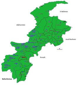 |
| Bannu | ||
| Dera Ismail Khan | ||
| Hazara | ||
| Kohat | ||
| Malakand | ||
| Mardan | ||
| Peshawar | ||
Administrative divisions of Shangla District | ||
|---|---|---|
| Capital |
| |
| Tehsils |
| |