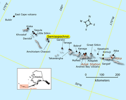
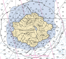
Semisopochnoi Island
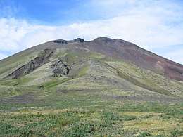 Eastern cone of Mount Cerebrus in the Semisopochnoi Caldera. | |
 | |
 Semisopochnoi | |
| Geography | |
|---|---|
| Location | Bering Sea |
| Coordinates | 51°57′05″N 179°36′03″E / 51.95139°N 179.60083°ECoordinates: 51°57′05″N 179°36′03″E / 51.95139°N 179.60083°E |
| Archipelago | Rat Islands |
| Area | 221.59 km2 (85.56 sq mi) |
| Length | 18 km (11.2 mi) |
| Width | 20 km (12 mi) |
| Administration | |
|
| |
| State |
|
Semisopochnoi Island or Unyak Island (obsolete Russian: Семисопочной, modern Russian: Семисопочный Semisopochny – "having seven hills"; Aleut: Unyax[1]) is part of the Rat Islands group in the western Aleutian Islands of Alaska. The island is uninhabited and provides an important nesting area for maritime birds. The island is of volcanic origin, containing several volcanoes including Mount Cerberus. It has a land area of 85.558 square miles (221.59 km2), measuring 18 kilometres (11 mi) in length and 20 kilometres (12 mi) in width.
At 179°46' East (+179.7667) (in the Eastern Hemisphere), the easternmost tip of Semisopochnoi is, by longitude, the easternmost land location in the United States and North America. Semisopochnoi sits only 14 minutes (0.2333 degrees) west of the 180th meridian.
Wildlife
Semisopochnoi has no native land mammals. Arctic foxes were introduced to the island during the 19th century for fur farming and removed in 1997. Most ground-nesting bird species (Aleutian cackling goose, rock ptarmigan) and most burrow-nesting seabirds (storm-petrels, ancient murrelets, Cassin's auklets, tufted puffins) were extirpated by foxes; Semisopochnoi Island is currently in the early stages of recovery. The island has remained free of Norway rats.
The large least and crested auklet colony near Sugarloaf Head is one of the largest among the nine auklet colonies in the Aleutian Islands. Crested auklets and least auklets breed in one colony, located on the south facing slopes of Sugarloaf Peak volcano and its associated cinder cones near Sugarloaf Head. Semisopochnoi Island also supports a significant population of red-faced cormorants.
In total, Semisopochnoi supports well over a million seabirds, most of which are least auklets or crested auklets.[2]
Geology
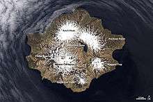
Semisopochnoi, the largest subaerial volcano of the western Aleutians, is 20 km wide at sea level and contains a caldera 8 km wide that formed as a result of collapse of a low-angle, dominantly basaltic volcano following the eruption of a large volume of dacitic pumice. The high point of the island is 1,221 meter Anvil Peak, a double-peaked cone that forms much of the island's northern part. The three-peaked, 774-meter high Mount Cerberus is a volcano within the caldera. Each of the peaks contains a summit crater; lava flows on the northern flank of Cerberus appear younger than those on the southern side. Other post-caldera volcanoes include the symmetrical 855 m high Sugarloaf Peak south-southeast of the caldera and Lakeshore Cone, a small cinder cone at the edge of Fenner Lake in the northeast part of the caldera. Most documented historical eruptions have originated from Cerberus, although Coats (1950) considered that both Sugarloaf and Lakeshore Cone within the caldera could have been active during historical time.[3][4][5]
Semisophochoi's last known volcanic eruption was in April 1987. A historic eruption of Semisopochnoi was reported in 1873, and at least four others may have occurred in the previous hundred years, but documentation is scanty. These eruptions apparently emanated from the flanks of Mount Cerberus; the most recent flow appears to be less than a century old.[6]
Easternmost North America location debate
The other contenders for the title of easternmost North America location are Nordost Rundingen, Greenland at 12°08' West (-12.1333) and Cape Spear, Newfoundland, Canada at 52°37' West (-52.6167) —which, along with Semisopochnoi, are all island locations. Cape St. Charles at 55° 37' West (-55.6167) on the Labrador Peninsula is the easternmost point of mainland North America. Cape Spear is the easternmost location relative to the geographic center of North America if Greenland is excluded because it is not politically part of North America. For this and other reasons, Cape Spear is traditionally considered to be the easternmost location in North America. The locations within the territory of the Aleutian Islands which lie exactly on the 180th meridian are by longitude simultaneously the easternmost and westernmost points of the United States.
References
- ↑ Bergsland, K. (1994). Aleut Dictionary. Fairbanks: Alaska Native Language Center.
- ↑ Audubon Site Profile, Semisopochnoi Island
- ↑ Global Volcanism Program, Semisopochnoi
- ↑ Coats R R, 1950. Volcanic activity in the Aleutian Arc. U S Geol Surv Bull, 974-B: 35-47
- ↑ Alaska Volcano Observatory, Semisopochnoi
- ↑ Wood, C. A., and Kienle, Juergen, (eds.), 1990, Volcanoes of North America: United States and Canada: New York, Cambridge University Press, 354 p.
External links
- Semisopochnoi Photos Photographs from Semisopochnoi Island, July 2008
- Google Earth view