Bogoslof Island
| Bogoslof Island | |
|---|---|
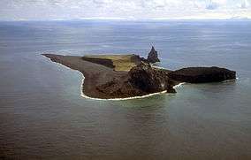 Aerial view, looking south (1994) | |
| Highest point | |
| Elevation | 492 ft (150 m) [1] |
| Coordinates | 53°55′38″N 168°02′04″W / 53.92722°N 168.03444°WCoordinates: 53°55′38″N 168°02′04″W / 53.92722°N 168.03444°W [1] |
| Geography | |
 Alaska | |
| Location | Aleutian Islands, Alaska |
| Geology | |
| Mountain type | Submarine volcano[2] |
| Volcanic arc | Aleutian Arc[2] |
| Last eruption |
December 20, 2016- August 30, 2017[3] |
| Designated | 1967 |
Bogoslof Island or Agasagook Island (Aleut: Aĝasaaĝux̂[4]) is the summit of a submarine stratovolcano located at the southern edge of the Bering Sea, 35 miles (56 km) northwest of Unalaska Island of the Aleutian Island chain. It has a land area of 319.3 acres (1.292 km2) and is uninhabited by people. The peak elevation of the island is 490 feet (150 m). It is 1,040 meters (3,410 ft) long and 1,512 m (4,961 ft) wide. The stratovolcano rises about 6,000 ft (1,800 m) from the seabed, but the summit is the only part that projects above sea level.[1] The island is believed to be relatively new, with the volcano being entirely below sea level before 1796, and most of the presently 300 acre island being formed by eruptions since 1900.
History
The first known emergence of the island above sea level was recorded during an underwater eruption in 1796. Since then, parts of the island have been successively added and eroded.[5] About 2,000 feet (610 m) northwest of Bogoslof, a small volcanic dome emerged in 1883 from the same stratovolcano and has become a stack rock formation known as Fire Island. On the southwest side of Bogoslof, another dome erupted in 1796; it is now called Castle Rock. Other eruptions have occurred in 1796-1804, 1806-1823, 1883-1895, 1906, 1907, 1909-1910, 1926-1928, 1992, and 2016-2017.[1] The island is a breeding site for seabirds, seals, and sea lions. An estimated 90,000 tufted puffins, guillemots, red-legged kittiwakes and gulls nest here.
In 1909, President Theodore Roosevelt designated Bogoslof and Fire Island a sanctuary for sea lions and nesting marine birds. Together, as the Bogoslof Wilderness, they are currently part of the Aleutian Islands unit of Alaska Maritime National Wildlife Refuge. In November 1967, Bogoslof Island was designated a National Natural Landmark by the National Park Service. The Bogoslof Island group was added to the National Wilderness Preservation System in 1970.
| Eruption year | Lava dome |
|---|---|
| 1796-1804 | Castle Rock |
| 1806-1823 | none? |
| 1883-1895 | Fire Island |
| 1906-1910 | none |
| 1926-1928 | unnamed |
| 1992 | unnamed |
| 2016-2017 | none |
2016-2017 Eruptions
A series of short volcanic eruptions on a nearly daily basis took place starting December 20, 2016, producing towering volcanic ash clouds and volcanic lightning, changing the geography of the island. As there are no cameras or monitoring stations on the island and the area is usually overcast, details were uncertain. However, when the weather became favorable, it was seen that a small vent slightly offshore of Bogoslof's northeast beach had erupted explosively, fracturing the original island in two, and forming a new, smaller island to the northeast.[6] Satellite images of the island showed that by December 25, 2016, the island had fractured into three smaller islands centered on what was thought to be the active vent of the eruption, gaining a net 1.2 acres (0.0049 km2), compared to its previous area of 71.2 acres (0.288 km2). Bogoslof continued to grow in the following weeks, reaching a size of 108.0 acres (0.437 km2) on January 11, 2017, and merging again into a single island. As of March 11, 2017, Bogoslof is 242 acres (0.98 km2) in size, having more than tripled in size, and forming into a large circular island around the central vent, and will likely continue to grow. A significant explosive eruption began at Bogoslof volcano at 02:08 UTC on 20 February (17:08 AKST on 19 February). Seismic and infrasound data show a series of short-lived explosive pulses through 02:45 UTC; seismicity has decreased slightly since then. Recent satellite images show a cloud as high as 25,000 ft asl.[7][8] A May 17 eruption sent ash 34,000 feet into the atmosphere.[9] On May 28, 2017, another eruption sent ash as high as 35,000 feet and raised Aviation Color Code to red, its highest level. Ash that rises above 20,000 feet is a threat to airliners in the area [10] The National Weather Service Alaska Aviation Weather Unit also issued an alert that the ash cloud may climb as high as 50,000 feet.[9]
As of May 10, 2017, it was estimated to have an area of about 319 acres, or 1.3 square kilometers.
The last eruption occurred on August 30, 2017, with slight volcanic activity continuing into early December, after which the volcano appeared to return to relative inactivity.
Gallery
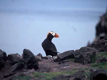 A tufted puffin on Bogoslof Island
 A fur seal colony on Bogoslof Island
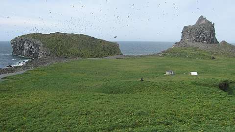 Surface of the island in August 2009, showing the 1926-1928 lava dome (left) and 1992 lava dome (right)
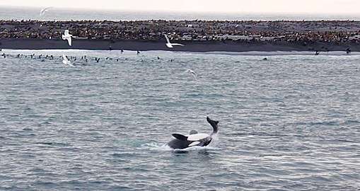 Orca feeding on a fur seal
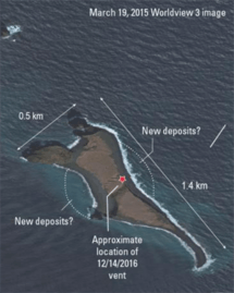 Satellite image of bogoslof in 2015, before the 2016-2017 eruptions which significantly altered the island's appearance.
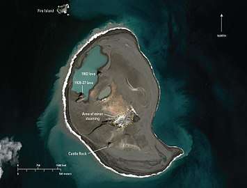 Bogoslof Island on April 20, 2018, showing the significant post-eruption terrain change.
See also
References
- 1 2 3 4 "Bogoslof Description and Statistics". Alaska Volcano Observatory. United States Geological Survey. Retrieved 2009-09-01.
- 1 2 "Bogoslof". Global Volcanism Program. Smithsonian Institution. Retrieved 2009-01-19.
- ↑ "AVO Bogoslof - Activity Page". Avo.alaska.edu. Retrieved 2018-04-30.
- ↑ Bergsland, K. (1994). Aleut Dictionary. Fairbanks: Alaska Native Language Center.
- ↑ Nunn, Patrick D. (2009). Vanished Islands and Hidden Continents of the Pacific. Honolulu: University of Hawaii Press. p. 140. ISBN 978-0-8248-3219-3.
- ↑ "BOGOSLOF UPDATES". avo.alaska.edu. USGS. Retrieved December 30, 2016.
- ↑ "USGS: Volcano Hazards Program". Volcanoes.usgs.gov. 2016-02-09. Retrieved 2017-12-16.
- ↑ Chaney, Eric. "Alaska Volcano Erupts 36 Times in 4 Months, Triples in Size". Weather Channel. Weather Channel. Retrieved 2017-03-23.
- 1 2 Don Crothers (2017-05-28). "Alaska Volcano Erupts, Flights May Be Disrupted". Inquisitr.com. Retrieved 2017-12-16.
- ↑ "Alaska Volcano Erupts Again; Aviation Alert Raised to Red". Bloomberg. 2017-05-28. Retrieved 2017-12-16.
External links
| Wikimedia Commons has media related to Bogoslof Island. |