Selby District
Coordinates: 53°46′37″N 1°04′44″W / 53.777°N 1.079°W
| Selby District | ||
|---|---|---|
| District | ||
| ||
 Shown within North Yorkshire | ||
| Sovereign state | United Kingdom | |
| Constituent country | England | |
| Region | Yorkshire and the Humber | |
| Shire county | North Yorkshire | |
| Admin. HQ | Selby | |
| Government | ||
| • Type | Selby District Council | |
| • Leadership: | Leader and Executive | |
| • Executive: | Conservative | |
| • MPs: | Nigel Adams | |
| Area | ||
| • Total | 231.4 sq mi (599.3 km2) | |
| Area rank | 70th | |
| Population (mid-2017 est.) | ||
| • Total | 87,900 | |
| • Rank | Ranked 275th | |
| • Density | 380/sq mi (150/km2) | |
| Time zone | UTC+0 (Greenwich Mean Time) | |
| • Summer (DST) | UTC+1 (British Summer Time) | |
| ONS code |
36UH (ONS) E07000169 (GSS) | |
| Ethnicity | 92.3% White | |
| Website | selby.gov.uk | |
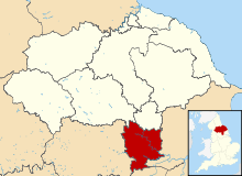
Selby District is a local government district of North Yorkshire, England. The local authority, Selby District Council, is based in the town of Selby and provides services to an area which includes Tadcaster and a host of villages. The Local Authority had a population of 83,449 at the 2011 Census.[1] It is the southern most district of North Yorkshire, and it borders the City of York, a unitary authority, the districts of the City of Leeds and the City of Wakefield, in West Yorkshire, the town of Doncaster, in South Yorkshire, the ceremonial county of the East Riding of Yorkshire, and the Borough of Harrogate.
The district was formed on 1 April 1974 by the merger of Selby Urban District, Selby Rural District and parts of Derwent Rural District, Hemsworth Rural District, Osgoldcross Rural District and Tadcaster Rural District. Of them, Derwent Rural District was in the historic East Riding of Yorkshire, but the rest were in the West Riding of Yorkshire.
On 1 April 1996, the parishes of Acaster Malbis, Askham Bryan, Askham Richard, Bishopthorpe, Copmanthorpe, Deighton, Dunnington, Elvington, Fulford, Heslington, Kexby, Naburn and Wheldrake were all transferred from the district to form part of the new City of York unitary authority. According to the 2001 census, those parishes had a population of 22,873.
Selby is twinned with Carentan in France and Filderstadt in Germany.
Towns and villages
Settlements in the district of Selby include:
- Barlby, Barlow, Bilbrough, Burn, Brayton
- Camblesforth, Carlton, Cawood, Church Fenton, Cliffe, Chapel Haddlesey
- Drax
- Eggborough, Escrick
- Gateforth
- Hambleton, Hemingbrough, Hensall, Hillam
- Kelfield, Kellington, Kirk Smeaton
- Lumby
- Monk Fryston
- North Duffield
- Osgodby
- Riccall
- Selby, Sherburn-in-Elmet, South Milford
- Tadcaster, Thorganby, Thorpe Willoughby
- Ulleskelf
- Wistow
Council


The Conservative party currently have a majority on the council, with Labour in opposition. In July 2018, a senior Tory defected to the Yorkshire Party.[2]
References
- ↑ "Local Authority population 2011". Neighbourhood Statistics. Office for National Statistics. Retrieved 20 February 2016.
- ↑ Laversuch, Chloe (23 July 2018). "Conservative councillor quits to join Yorkshire Party". The York Press. Retrieved 12 October 2018.
External links
| Wikimedia Commons has media related to Selby. |
