Chapel Haddlesey
| Chapel Haddlesey | |
|---|---|
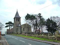 St John the Baptist's parish church, Hirst Road, Chapel Haddlesey, seen from the northwest | |
 Chapel Haddlesey Chapel Haddlesey shown within North Yorkshire | |
| Population | 202 (2011)[1] |
| OS grid reference | SE581452 |
| District | |
| Shire county | |
| Region | |
| Country | England |
| Sovereign state | United Kingdom |
| Post town | Selby |
| Postcode district | YO8 |
| Police | North Yorkshire |
| Fire | North Yorkshire |
| Ambulance | Yorkshire |
| EU Parliament | Yorkshire and the Humber |
Chapel Haddlesey is a village and civil parish in the Selby district of North Yorkshire, England. The village used to be in the Barkston Ash Wapentake and up until 1974, it was in the West Riding of Yorkshire.[2] The village is just east off the A19 road, which crosses the River Aire on Haddlesey Bridge.[3]
At the west end of the village is the Church of England primary school, which has an age range of 4–11, and an average of 50 pupils on the roster.[4] The St John the Baptist Church is at the east end of the village.[5]The church was built in 1836 on the site of a previous religious house that dated back to the 14th century. Originally the church was a chapel of ease, as it was part of the parish of Birkin. It formed its own parish, along with the nearby villages of Temple Hirst and Hirst Courtney in 1873.[6][7]
Boats used to travel up the River Aire to the south of the village and a weir and lock (Haddlesey Old Lock) were constructed in 1702. The lock became redundant upon the opening of the Selby Canal in 1778, but the weir was kept in place to allow headwaters to build up and keep the mouth form the canal at Selby in deep water. The canal mouth is at West Haddlesey, which is just 0.62 miles (1 km) to the west of Chapel Haddlesey.[3][8][9]
In 2016, Haddlesey Old Lock was converted into a hydro power station to generate enough electricity for 440 homes.[10] The bottom of the lock is also the normal tidal limit for the River Aire.[3][11]
References
- ↑ "Parish population 2011". Neighbourhood Statistics. Office for National Statistics. Retrieved 14 August 2015.
- ↑ "Chapel Haddlesey Tn/CP through time". www.visionofbritain.org.uk. Retrieved 10 January 2018.
- 1 2 3 "290" (Map). York. 1:25,000. Explorer. Ordnance Survey. 2015. ISBN 9780319244876.
- ↑ "Chapel Haddlesey Church of England Voluntary Controlled Primary School: School Inspection Report 2016" (PDF). reports.ofsted.gov.uk. 20 June 2016. p. 8. Retrieved 10 January 2018.
- ↑ "The Church of St John the Baptist, Haddlesey -A Church Near You". www.achurchnearyou.com. Retrieved 10 January 2018.
- ↑ "Church of England, Chapel Haddlesey, St. John the Baptist, parish - Borthwick Catalogue". borthcat.york.ac.uk. Retrieved 10 January 2018.
- ↑ The ancient parish of Birkin: historical and genealogical information at GENUKI (Chapel Haddlesey was in this parish).
- ↑ "Chapel Haddlesey update | Aire Rivers Trust". aireriverstrust.org.uk. Retrieved 10 January 2018.
- ↑ "River Aire, Kellington Marsh to West Haddlesey". www.penninewaterways.co.uk. Retrieved 10 January 2018.
- ↑ "Chapel Haddlesey – Old Lock House Hydro Electric Generation Scheme" (PDF). aireriverstrust.org.uk. UK Hydro Ltd. September 2016. Retrieved 10 January 2018.
- ↑ Kidd, Marie-Claire (2 August 2014). "Promises of a new wealth of fish in our waterways". The Yorkshire Post. Retrieved 10 January 2018.