Seine-Saint-Denis
| Seine-Saint-Denis | ||
|---|---|---|
| Department | ||
 | ||
| ||
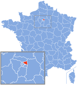 Location of Seine-Saint-Denis in France | ||
| Coordinates: 48°54′N 02°29′E / 48.900°N 2.483°ECoordinates: 48°54′N 02°29′E / 48.900°N 2.483°E | ||
| Country | France | |
| Region | Île-de-France | |
| Prefecture | Bobigny | |
| Subprefectures |
Le Raincy Saint-Denis | |
| Government | ||
| • President of the General Council | Claude Bartolone (PS) | |
| Area1 | ||
| • Total | 236 km2 (91 sq mi) | |
| Population (2013) | ||
| • Total | 1,552,482 | |
| • Rank | 6th | |
| • Density | 6,600/km2 (17,000/sq mi) | |
| Time zone | UTC+1 (CET) | |
| • Summer (DST) | UTC+2 (CEST) | |
| Department number | 93 | |
| Arrondissements | 3 | |
| Cantons | 21 | |
| Communes | 40 | |
| ^1 French Land Register data, which exclude estuaries, and lakes, ponds, and glaciers larger than 1 km2 | ||

Seine-Saint-Denis (French pronunciation: [sɛnsɛ̃d(ə)ni]) is a French department located in the Île-de-France region. Locally, it is often referred to colloquially as quatre-vingt treize or neuf trois (i.e. "ninety-three" or "nine three"), after its official administrative number, 93.
The learned and rarely used demonym for the inhabitants is Séquano-Dionysiens; more common is Dionysiens.
Geography
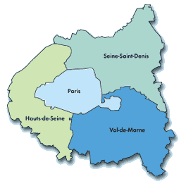
Seine-Saint-Denis is located to the northeast of Paris. It has a surface area of only 236 km², making it one of the smallest departments in France. Seine-Saint-Denis and two other small departments, Hauts-de-Seine and Val-de-Marne, form a ring around Paris, known as the Petite Couronne ("little crown"). Since 1 January 2016, together with Paris, they form the area of Greater Paris.
Administration
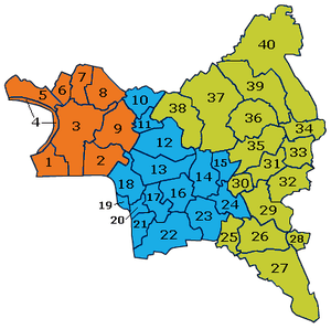
Seine-Saint-Denis is made up of three departmental arrondissements and 40 communes:
History
Seine-Saint-Denis was created in January 1968, through the implementation of a law passed in July 1964. It was formed from the part of the (hitherto larger) Seine department to the north and north-east of the Paris ring road (and the line of the old city walls), together with a small slice taken from Seine-et-Oise.
Seine-Saint-Denis has a history as a veritable left-wing stronghold, belonging to the ceinture rouge (red belt) of Paris. The French Communist Party especially has maintained a continued strong presence in the department, and still controls the city councils in cities such as Saint-Denis, Montreuil and La Courneuve. Until 2008, Seine-Saint-Denis and Val-de-Marne were the only departments where the Communist Party had a majority in the general councils but the 2008 cantonal elections saw the socialists become the strongest group at the Seine-Saint-Denis general council (while the Communist Party gained a majority in Allier and lost it in 2015).
A commune of Seine-Saint-Denis, Clichy-sous-Bois, was the scene of the death of two youths which sparked the nationwide riots of autumn 2005. In October and November, 9,000 cars were burned and 3,000 rioters were arrested.
In 2018, the department had the highest crime rate in metropolitan France.[1] In 2017, the area was the theatre of 18% of all drug offences in metropolitan France.[1]
Demographics
Seine-Saint-Denis is the French department with the highest proportion of immigrants: 21.7% at the 1999 census (see table below). This figure does not include the children of immigrants born on French soil as well as some native elites from former French colonies and people who came from overseas France. The ratio of ethnic minorities is difficult to estimate accurately as French law prohibits the collection of ethnic data for census taking purposes.
In 2005, 56.7% of young people under 18 were of foreign origin including 38% of African origin (22% from Maghreb and 16% from Sub-Saharan Africa).
In 2018, the poverty rate was twice the national average at 28%, the unemployment rate was 3 percentage above the national average and 4 percentage points above the Île-de-France average at 12.7%. In 2018, it was estimated that 8-20% of the population in the department were illegal immigrants.[2] Brittany M. Hughes of MRCTV estimates that there are more than 300,000 illegal immigrants in Seine-Saint-Denis.[3]
Education
A education study confirmed falling levels of literacy in the area, where the fraction of pupils who had 25 errors or more increased from 5.4% in 1987 to 19.8% in 2015.[1]
Place of birth of residents
| |||||||||||||||||||
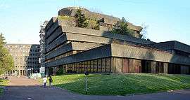
Tourism
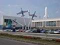
.jpg)

Miscellaneous topics
Seine-Saint-Denis was scheduled to be the site of a 2004 International Exhibition. However, this event was cancelled.
References
- 1 2 3 "N° 1014 - Rapport d'information de MM. François Cornut-Gentille et Rodrigue Kokouendo déposé en application de l'article 146-3 du règlement, par le comité d'évaluation et de contrôle des politiques publiques sur l'évaluation de l'action de l'État dans l'exercice de ses missions régaliennes en Seine-Saint-Denis". www.assemblee-nationale.fr. Retrieved 2018-07-08.
- ↑ "Immigration clandestine : la Seine-Saint-Denis débordée". FIGARO (in French). 2018-07-04. Retrieved 2018-07-08.
- ↑ Hughes, Brittany M. "'Pro-Refugee' Paris Now Has 300K Illegal Migrants Crammed Into ONE Neighborhood". MRCTV. © 2018 Media Research Center. Retrieved 31 July 2018.
Further reading
- Bédarida, Catherine (29 September 2008). "Seine-Saint-Denis, naissance d'un ghetto" [Seine-Saint-Denis, birth of a ghetto]. Le Monde.
- Kefi, Ramses (30 January 2015). "Pourquoi toujours le 9-3 ?" [Why is it always Seine-Saint-Denis?]. L'Obs.
External links
| Wikimedia Commons has media related to: |
- Seine-Saint-Denis General Council (in French)
- Prefecture website (in French)
- Seine-Saint-Denis Tourist Board


| Authority control |
|---|