Arrondissement of Le Raincy
| Le Raincy | |
|---|---|
| Arrondissement | |
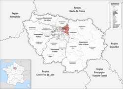 Location of Le Raincy in Île-de-France | |
| Country | France |
| Region | Île-de-France |
| Department | Seine-Saint-Denis |
| Communes | 22 |
| Subprefecture | Le Raincy |
| Area¹ | |
| • Total | 149.6 km2 (57.8 sq mi) |
| Population (2013) | |
| • Total | 544,779 |
| • Density | 3,600/km2 (9,400/sq mi) |
| ¹ French Land Register data, which exclude lakes, ponds, and glaciers larger than 1 km² as well as the estuaries of rivers. | |
The arrondissement of Le Raincy is an arrondissement of France in the Seine-Saint-Denis department in the Île-de-France region. Since the January 2017 reorganization of the arrondissements of Seine-Saint-Denis, it has 22 communes.[1]
Composition
Cantons
The cantons of the arrondissement of Le Raincy are:
- Aulnay-sous-Bois
- Le Blanc-Mesnil
- Bondy (partly)
- La Courneuve (partly)
- Drancy
- Gagny
- Livry-Gargan
- Montreuil-1 (partly)
- Noisy-le-Grand
- Sevran
- Tremblay-en-France
- Villemomble
Communes
The communes of the arrondissement of Le Raincy, and their INSEE codes, are:
- Aulnay-sous-Bois (93005)
- Le Blanc-Mesnil (93007)
- Le Bourget (93013)
- Clichy-sous-Bois (93014)
- Coubron (93015)
- Drancy (93029)
- Dugny (93030)
- Gagny (93032)
- Gournay-sur-Marne (93033)
- Livry-Gargan (93046)
- Montfermeil (93047)
- Neuilly-Plaisance (93049)
- Neuilly-sur-Marne (93050)
- Noisy-le-Grand (93051)
- Les Pavillons-sous-Bois (93057)
- Le Raincy (93062)
- Rosny-sous-Bois (93064)
- Sevran (93071)
- Tremblay-en-France (93073)
- Vaujours (93074)
- Villemomble (93077)
- Villepinte (93078)
References
- ↑ "Arrêté préfectoral, 30 December 2016, p 25" (PDF). Retrieved 2017-08-01.
External links
This article is issued from
Wikipedia.
The text is licensed under Creative Commons - Attribution - Sharealike.
Additional terms may apply for the media files.