Second principal meridian
U.S. Bureau of Land Management map showing the principal meridians in Illinois, Indiana, and Ohio

Sign along Indiana Route 37, pointing to meeting of the Second Principal Meridian and the Indiana base line
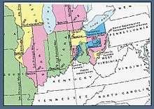
The second principal meridian, or Paoli Meridian, coincides with 86° 28′ of longitude west from Greenwich, starts from a point two and one half miles west of the confluence of the Little Blue and Ohio rivers, runs north to the northern boundary of Indiana, and, with the base line in latitude 38° 28′ 20″, governs the surveys in Indiana and part of those in Illinois.
Sources
- Raymond, William Galt (1914). Plane Surveying for Use in the Classroom and Field (via Google Books). New York: American Book Company.
- "Chapter Five: Land Surveying". Survey Manual (PDF). Springfield, Illinois: Illinois Department of Transportation, Bureau of Design and Environment. 2003-02-28. pp. 5–5. Retrieved 2008-10-30.
See also
External links
- "Cadastral Survey [second principal meridian]". U.S. Bureau of Land Management. Archived from the original on 2013-02-22. Retrieved 2012-09-29.
- "Principal Meridians and Base Lines". U.S. Bureau of Land Management. Archived from the original on 2012-10-18. Retrieved 2012-09-29.
- "The Second Principal Meridian, Paoli, Indiana". Principal Meridian Project. Retrieved 2012-09-29.
- "Second Principal Meridian". The Center for Land Use Interpretation. Retrieved 2012-09-29.
- "Hoosier National Forest, Initial Point". U.S. Forest Service. Retrieved 2012-10-07.
Coordinates: 38°28′10.02″N 86°27′21.17″W / 38.4694500°N 86.4558806°W
This article is issued from
Wikipedia.
The text is licensed under Creative Commons - Attribution - Sharealike.
Additional terms may apply for the media files.