Third principal meridian
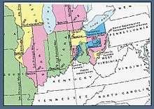
U.S. Bureau of Land Management map showing the principal meridians in Illinois, Indiana, and Ohio
The third principal meridian begins at the mouth of the Ohio River and extends north to the northern boundary of the state of Illinois, and with the base line in latitude 38° 28′ 20″, governs the surveys in the state east of the third principal meridian, with the exception of those projected from the second principal meridian, and the surveys on the west, to the Illinois River. This meridian is nearly coincident with 89° 10′ 15″ of west longitude from Greenwich.
External links
- "The Third Principal Meridian". Principal Meridian Project. Retrieved 2012-09-15.
- "Third Principal Meridian". The Center for Land Use Interpretation. Retrieved 2012-09-15.
- "Historic Marker: The Third Principal Meridian". Illinois State Historical Society. Retrieved 2016-10-28.
Sources
- Raymond, William Galt (1914). Plane Surveying for Use in the Classroom and Field (via Google Books). New York: American Book Company.
- "Chapter Five: Land Surveying". Survey Manual (PDF). Springfield, Illinois: Illinois Department of Transportation, Bureau of Design and Environment. 2003-02-28. pp. 5–5. Retrieved 2008-10-30.
Coordinates: 38°28′26″N 89°08′40″W / 38.47389°N 89.14444°W
This article is issued from
Wikipedia.
The text is licensed under Creative Commons - Attribution - Sharealike.
Additional terms may apply for the media files.