Mount Diablo meridian
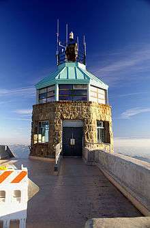
Summit beacon tower atop Mt. Diablo. The initial point marker lies within this tower.
The Mount Diablo meridian, established in 1851, is a principal meridian extending north and south from its initial point atop Mount Diablo in California. Established under the U.S. Public Land Survey System, it is used to describe lands in most of northern California and all of Nevada.[1] Mount Diablo also marks the baseline at latitude 37°52′54″N.[2]
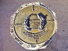
Mount Diablo Memorial Marker
See also
References
- ↑
- John W. Pettley, PLS. "Mount Diablo Survey Point Establishes Property Boundaries in California and Nevada". Mount Diablo Surveyors Historical Society. Retrieved 2012-09-27.
- ↑
- "Mount Diablo Meridian". U.S. Bureau of Land Management. Archived from the original on 2017-01-06. Retrieved 2012-09-27.
External links
- "Mount Diablo Meridian, San Francisco, CA". Principal Meridian Project. Retrieved 2012-09-27.
- "Cadastral Survey: Principal Meridians and Base Lines". U.S. Bureau of Land Management. Archived from the original on 2012-10-18. Retrieved 2012-09-27.
Coordinates: 37°52′54″N 121°54′51″W / 37.88167°N 121.91417°W
This article is issued from
Wikipedia.
The text is licensed under Creative Commons - Attribution - Sharealike.
Additional terms may apply for the media files.