First principal meridian
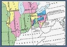
U.S. Bureau of Land Management map showing the first four principal meridians
The first principal meridian is a meridian that began[1] at the junction of the Ohio River and Great Miami River. It extends north on the boundary line between the states of Ohio and Indiana, and roughly approximates to the meridian of longitude 84° 48′ 50″ west from Greenwich. The ranges of the public surveys in the state of Ohio, west of the Scioto River, are (in part) numbered from this meridian.
See also
References
- ↑ While civil boundaries and rivers can "move," surveying meridians and monuments remain "fixed."
- Raymond, William Galt (1914). Plane Surveying for Use in the Classroom and Field (via Google Books). New York: American Book Company.
- Linklater, Andro. Measuring America.
External links
- "Cadastral Survey". U.S. Bureau of Land Management. Retrieved 2012-09-29.
- "Cadastral Survey, Principal Meridians and Base Lines". U.S. Bureau of Land Management. Retrieved 2012-09-29.
- "First Principal Meridian, Monroeville, IN". Principal Meridian Project. Retrieved 2012-09-29.
- "First Principal Meridian". The Center for Land Use Interpretation. Retrieved 2012-09-29.
Coordinates: 40°59′21.74″N 84°48′11.69″W / 40.9893722°N 84.8032472°W
This article is issued from
Wikipedia.
The text is licensed under Creative Commons - Attribution - Sharealike.
Additional terms may apply for the media files.