Angermünde
| Angermünde | ||
|---|---|---|
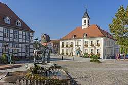 Market Place & Townhall | ||
| ||
 Angermünde Location of Angermünde within Uckermark district 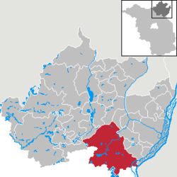 | ||
| Coordinates: 53°02′0″N 14°00′0″E / 53.03333°N 14.00000°ECoordinates: 53°02′0″N 14°00′0″E / 53.03333°N 14.00000°E | ||
| Country | Germany | |
| State | Brandenburg | |
| District | Uckermark | |
| Government | ||
| • Mayor | Frederik Bewer | |
| Area | ||
| • Total | 326.44 km2 (126.04 sq mi) | |
| Elevation | 50 m (160 ft) | |
| Population (2017-12-31)[1] | ||
| • Total | 13,837 | |
| • Density | 42/km2 (110/sq mi) | |
| Time zone | CET/CEST (UTC+1/+2) | |
| Postal codes | 16278 | |
| Dialling codes | 03331 | |
| Vehicle registration | UM | |
| Website | www.angermuende.de | |

Angermünde (German pronunciation: [aŋɐˈmʏndə] (![]()
The population is about 10,000, but the population has been rapidly falling as its traditional industrial base (enamel-working) has declined. An administrative sub-centre of its district, it has several Protestant churches, a former Franciscan church, a number of schools of higher learning and a recently refurbished historic marketplace with an old town hall. Located in the game-filled forests of the Uckermark, with its many lakes, it now relies heavily on tourism and the sources of revenue linked to it.
Name
The town is named for its position on the Mündesee.
History
The town was the site of a 1420 victory of Frederick I of Brandenburg over the Pomeranians.[2]
In the 19th century, the town was the seat of a Prussian circle in the province of Brandenburg and linked to Berlin by the Berlin–Stettin (now Szczecin, Poland) railway.[3] Angermünde station then served as the junction for sidelines servicing Prenzlau, Bad Freienwalde, and Schwedt.[2]
In the 20th century, it formed part of East Germany.
Demography
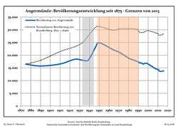 Development of population since 1875 within the current Boundaries (Blue Line: Population; Dotted Line: Comparison to Population development in Brandenburg state; Grey Background: Time of Nazi Germany; Red Background: Time of communist East Germany)
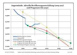 Recent Population Development and Projections (Population Development before Census 2011 (blue line); Recent Population Development according to the Census in Germany in 2011 (blue bordered line); Projection by the Brandenburg state for 2005-2030 (yellow line); Projection by the Brandenburg state for 2014-2030 (red line); Projection by the Bertelsmann Foundation for 2012-2030 (green line)
| Angermünde: Population development within the current boundaries (2017)[4] | ||||||||||||||||||||||||||||||||||||||||||||||||||||||||||||||||||||||||||||||||||||||||||||||||||||||||||||||||||||||||||||||||||||||
|---|---|---|---|---|---|---|---|---|---|---|---|---|---|---|---|---|---|---|---|---|---|---|---|---|---|---|---|---|---|---|---|---|---|---|---|---|---|---|---|---|---|---|---|---|---|---|---|---|---|---|---|---|---|---|---|---|---|---|---|---|---|---|---|---|---|---|---|---|---|---|---|---|---|---|---|---|---|---|---|---|---|---|---|---|---|---|---|---|---|---|---|---|---|---|---|---|---|---|---|---|---|---|---|---|---|---|---|---|---|---|---|---|---|---|---|---|---|---|---|---|---|---|---|---|---|---|---|---|---|---|---|---|---|---|
|
|
| ||||||||||||||||||||||||||||||||||||||||||||||||||||||||||||||||||||||||||||||||||||||||||||||||||||||||||||||||||||||||||||||||||||
Mayors
- 1989–1998: Wolf-Hugo Just
- 1998–2016: Wolfgang Krakow (SPD)
- since 2016: Frederik Bewer (independent)
Frederik Bewer was elected in May 2016 with 95,3 % of the votes for a term of eight years.[5]
Gallery
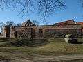 City wall
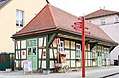 Touristinformation
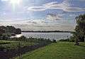 The lake Mündesee in Angermünde.
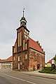 Holy Spirit Chapel
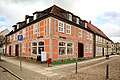 Timbered house
 City Church St. Mary
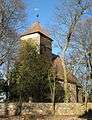 Church in Schmiedeberg
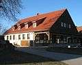 Alcove house in Schmiedeberg
 Alcove house in Schmiedeberg
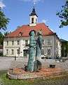
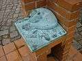
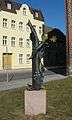
- Fountain and sculptures by Christian Uhlig
Sons and daughters of the town

- Friedrich Heinrich von der Hagen (1780–1856), German scholar
- Albert Manthe (1847–1928), sculptor
- Hermann Dietrich (1856–1930), born in Schmargendorf, politician (DNVP), member of Reichstag
- Ehm Welk (1884–1966), writer
- Hans-Erich Voss (1897–1969), Vice Admiral in World War II
- Günter Reimann (1904–2005), economist and journalist
- Heinrich Borgmann (1912–1945), adjutant of Adolf Hitler
- Hartmut Losch (1943–1997), athlete, European champion in discus throw
- Maik Heydeck (born 1965), boxer
- Julia Jäger (born 1970), actress
Notes
- ↑ "Bevölkerung im Land Brandenburg nach amtsfreien Gemeinden, Ämtern und Gemeinden 31. Dezember 2017 (Fortgeschriebene amtliche Einwohnerzahlen auf Grundlage des Zensus 2011)". Amt für Statistik Berlin-Brandenburg (in German). 2018.
- 1 2 EB (1911).
- ↑ EB (1878).
- ↑ Detailed data sources are to be found in the Wikimedia Commons.Population Projection Brandenburg at Wikimedia Commons
- ↑ Ergebnis der Bürgermeisterstichwahl am 8. Mai 2016
References

External links
| Wikimedia Commons has media related to Angermünde. |
- Official Website (in German)
| Authority control |
|---|