Overview
A road bridge links Mescherin with the Polish-Pomeranian town of Gryfino (Greifenhagen) across the river. The nearest city is Szczecin (Stettin), about 20 km to the north. Mescherin is located on the northern edge of Lower Oder Valley National Park.
On December 31, 2002, the municipalities of Neurochlitz, Radekow and Rosow were incorporated into Mescherin. In Rosow, a 13th-century church serves as a joint German-Polish memorial site for the Flight and expulsion of Germans during and after World War II and the resettlement of Poles from Soviet-occupied Polish territory into eastern German provinces which became Polish in 1945. Rosow was chosen as the Pomeranian village became a border checkpoint of both the federal highway Bundesstraße 2 and the Berlin-Szczecin railway.
Demography
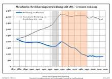
Development of population since 1875 within the current Boundaries (Blue Line: Population; Dotted Line: Comparison to Population development in Brandenburg state; Grey Background: Time of
Nazi Germany; Red Background: Time of communist
East Germany)
Mescherin: Population development
within the current boundaries (2017)[2] |
|---|
| Year | Pop. | ±% p.a. |
|---|
| 1875 | 2,221 | — |
|---|
| 1890 | 1,950 | −0.86% |
|---|
| 1910 | 1,948 | −0.01% |
|---|
| 1925 | 1,711 | −0.86% |
|---|
| 1933 | 1,622 | −0.67% |
|---|
| 1939 | 1,630 | +0.08% |
|---|
| 1946 | 1,914 | +2.32% |
|---|
| 1950 | 1,982 | +0.88% |
|---|
| 1964 | 1,549 | −1.75% |
|---|
| 1971 | 1,460 | −0.84% |
|---|
| 1981 | 1,021 | −3.51% |
|---|
| 1985 | 964 | −1.43% |
|---|
| 1989 | 864 | −2.70% |
|---|
| 1990 | 856 | −0.93% |
|---|
| | Year | Pop. | ±% p.a. |
|---|
| 1991 | 809 | −5.49% |
|---|
| 1992 | 821 | +1.48% |
|---|
| 1993 | 827 | +0.73% |
|---|
| 1994 | 859 | +3.87% |
|---|
| 1995 | 856 | −0.35% |
|---|
| 1996 | 848 | −0.93% |
|---|
| 1997 | 843 | −0.59% |
|---|
| 1998 | 824 | −2.25% |
|---|
| 1999 | 863 | +4.73% |
|---|
| 2000 | 857 | −0.70% |
|---|
| 2001 | 832 | −2.92% |
|---|
| 2002 | 809 | −2.76% |
|---|
| 2003 | 800 | −1.11% |
|---|
| 2004 | 785 | −1.88% |
|---|
| | Year | Pop. | ±% p.a. |
|---|
| 2005 | 776 | −1.15% |
|---|
| 2006 | 778 | +0.26% |
|---|
| 2007 | 783 | +0.64% |
|---|
| 2008 | 777 | −0.77% |
|---|
| 2009 | 788 | +1.42% |
|---|
| 2010 | 785 | −0.38% |
|---|
| 2011 | 760 | −3.18% |
|---|
| 2012 | 791 | +4.08% |
|---|
| 2013 | 784 | −0.88% |
|---|
| 2014 | 795 | +1.40% |
|---|
| 2015 | 786 | −1.13% |
|---|
| 2016 | 802 | +2.04% |
|---|
| 2017 | 825 | +2.87% |
|---|
|
References
 |
Wikimedia Commons has media related to Mescherin. |
|
Wikimedia Commons has media related to Mescherin. |
Authority control  | |
|---|