Schunter
| Schunter | |
|---|---|
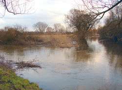 Confluence of the Schunter (left) and Oker river near Groß Schwülper. | |
| Country | Germany |
| Physical characteristics | |
| Main source |
Elm 175 m (574 ft) 52°10′56″N 10°50′57″E / 52.18222°N 10.84917°E |
| River mouth |
Oker 52°20′37″N 10°26′22″E / 52.34361°N 10.43944°ECoordinates: 52°20′37″N 10°26′22″E / 52.34361°N 10.43944°E |
| Length | 58.3 km (36.2 mi) [1] |
| Basin features | |
| Progression | Oker→ Aller→ Weser→ North Sea |
| Basin size | 597 km2 (231 sq mi) [1] |
The Schunter is a river in Lower Saxony, Germany, with a length of 58 km, right tributary of the Oker. It originates in the Elm hills near Räbke west of Helmstedt, flows northward to Süpplingenburg, then turns westward and joins the Oker at Schwülper, downstream of Braunschweig (Brunswick). Another municipality on the Schunter is Lehre.
The river was first mentioned as Schuntra in a 781 deed. The name may be of Slavic origin as sukątora means "with many angles". Its clear spring waters formerly supplied the paper mills of Räbke. In the 18th century it was also used for timber rafting of logs harvested in the Elm range.
Tributaries

Springs in the Elm.
|
Left tributaries (from source to mouth): |
Right tributaries:
|
Sources
- Theodor Müller: Schifffahrt und Flößerei auf der Schunter im 18. Jahrhundert. In: Forschungen zur Braunschweigischen Geschichte, 1954, 135-159
- Gunhild Ruben: Herzog Karl I. und der Schifffahrtskanal vom Elm nach Braunschweig. Braunschweig 2002
- Uwe Kleineberg: Chronik 975 Jahre Wenden. Braunschweig 2006, p.135ff
References
This article is issued from
Wikipedia.
The text is licensed under Creative Commons - Attribution - Sharealike.
Additional terms may apply for the media files.