Räbke
| Räbke | ||
|---|---|---|
| ||
 Räbke Location of Räbke within Helmstedt district 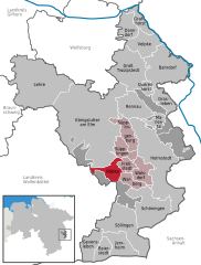  | ||
| Coordinates: 52°12′N 10°53′E / 52.200°N 10.883°ECoordinates: 52°12′N 10°53′E / 52.200°N 10.883°E | ||
| Country | Germany | |
| State | Lower Saxony | |
| District | Helmstedt | |
| Municipal assoc. | Nord-Elm | |
| Government | ||
| • Mayor | Rainer Angerstein | |
| Area | ||
| • Total | 11.35 km2 (4.38 sq mi) | |
| Elevation | 134 m (440 ft) | |
| Population (2017-12-31)[1] | ||
| • Total | 701 | |
| • Density | 62/km2 (160/sq mi) | |
| Time zone | CET/CEST (UTC+1/+2) | |
| Postal codes | 38375 | |
| Dialling codes | 05355 | |
| Vehicle registration | HE | |
| Website | www.raebke.de | |

Räbke is a municipality in the district of Helmstedt, in Lower Saxony, Germany. It is part of the collective municipality (Samtgemeinde) of Nord-Elm. The village is situated north of the wooded Elm hill range at the Schunter river.
The settlement was first mentioned as Ridepe in a 1205 deed. Since the 16th century Räbke was known for its paper mills meeting the needs of the University of Helmstedt.

The Lutheran church
References
| Authority control |
|---|
This article is issued from
Wikipedia.
The text is licensed under Creative Commons - Attribution - Sharealike.
Additional terms may apply for the media files.