Weser
| Weser | |
| Werser (Low German) | |
| River | |
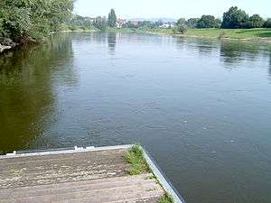 The Weser near Bad Oeynhausen | |
| Name origin: *weis, Germanic, meaning to flow | |
| Country | Germany |
|---|---|
| Bundesland | Bremen, Lower Saxony, North Rhine-Westphalia, Thuringia, Hessen |
| Tributaries | |
| - left | Diemel, Emmer, Werre, Große Aue, Hunte |
| - right | Aller, Lesum |
| Cities | Bremerhaven, Bremen, Minden, Hamelin, Hann. Münden, Kassel, Fulda |
| Source | |
| - location | Confluence of the Fulda and Werra Rivers in Hann. Münden |
| - elevation | 116 m (381 ft) |
| - coordinates | 51°25′17″N 9°38′53″E / 51.42139°N 9.64806°E |
| Mouth | Wadden Sea/North Sea |
| - location | Bremerhaven/Nordenham |
| - elevation | 0 m (0 ft) |
| - coordinates | 53°32′8″N 8°33′56″E / 53.53556°N 8.56556°ECoordinates: 53°32′8″N 8°33′56″E / 53.53556°N 8.56556°E |
| Length | 452 km (281 mi) |
| Basin | 46,306 km2 (17,879 sq mi) |
| Discharge | |
| - average | 327 m3/s (11,548 cu ft/s) |
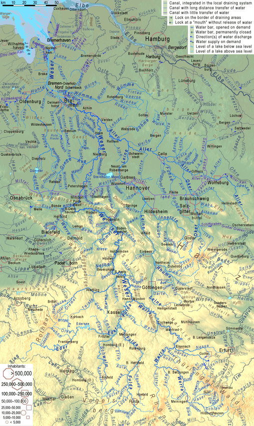
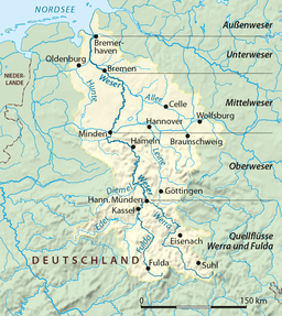 Watershed of the Weser | |

The Weser (German pronunciation: [ˈveːzɐ]) is a river in Northwestern Germany. Formed at Hannoversch Münden by the confluence of the rivers Fulda and Werra, it flows through Lower Saxony, then reaching the Hanseatic city of Bremen (see: Hanseatic League), before emptying 50 km (31 mi) further north at Bremerhaven into the North Sea. On the opposite (west) bank is the town of Nordenham at the foot of the Butjadingen Peninsula; thus, the mouth of the river is in Lower Saxony. The Weser has an overall length of 452 km (281 mi). Together with its Werra tributary, which originates in Thuringia, its length is 744 km (462 mi).
Etymology
Linguistically, the names of both rivers, Weser and Werra, go back to the same source, the differentiation being caused by the old linguistic border between Upper and Lower German, which touched the region of Hannoversch Münden.
The name Weser parallels the names of other rivers, such as the Wear in England and the Vistula in Poland, all of which are ultimately derived from the root *weis- "to flow", which gave Old English/Old Frisian wāse "mud, ooze", Old Norse veisa "slime, stagnant pool", Dutch waas "haze; soggy land" (see Waasland), Old Saxon waso "wet ground, mire", Old High German wasal "rain", and French vase "mud, sludge".
Course
The Weser River is the longest river whose course reaches the sea and lies entirely within German national territory.
The upper part of its course leads through a hilly region called the Weserbergland. It extends from the confluence of the Fulda and the Werra to the Porta Westfalica, where it runs through a gorge between two mountain chains, the Wiehengebirge in the west and the Weserbergland in the east.
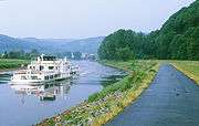
Between Minden and the North Sea, humans have largely canalised the river, permitting ships up to 1,200 tons to navigate it. Eight hydroelectric dams stand along its length. It is linked to the Dortmund-Ems Canal via the Coastal Canal, and another canal links it at Bremerhaven to the Elbe River. A large reservoir on the Eder River, the main tributary of the Fulda, is used to regulate water levels on the Weser so as to ensure adequate depth for shipping throughout the year. The dam, built in 1914, was bombed and severely damaged by British aircraft in May 1943, causing massive destruction and about 70 deaths downstream, but was rebuilt within four months. As of 2013, the Edersee Reservoir, a major summer resort area, provides substantial hydroelectricity.

 "Upper" Weser, in reality the central section between the upper courses Werra and Fulda, and the lowland section
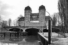 Mittelland Canal/ River Weser Lock in Minden taken in 1977
_North_(RLH).jpg) View north of the River Weser and the road bridge at Minden
View north of the River Weser and the road bridge at Minden_South_To_Porta_West_Falica_(RLH).jpg) Southern view of the River Weser from the road bridge at Minden in 1977
Southern view of the River Weser from the road bridge at Minden in 1977
The Weser enters the North Sea in the southernmost part of the German Bight. In the North Sea, it splits into two arms representing the ancient riverbed at the end of the last ice age. These sea arms are called Alte Weser (old Weser) and Neue Weser (new Weser). They represent the major waterways for ships heading for the harbors of Bremerhaven, Nordenham, and Bremen. The Alte Weser lighthouse marks the northernmost point of the Weser. This lighthouse replaced the historic and famous Roter Sand lighthouse in 1964.
Tributaries
The largest tributary of the Weser is the Aller, which joins south of Bremen. The tributaries of the Weser and the Werra (from source to mouth) are:
Modes of the list:
- Listed upstream, but sides seen with the flow
- Distances ("km …") from the hydrographical limit towards the sea
- "II", "III"and "IV" mark distances of secondary/tertiary tributaries from the confluence with the Weser etc.
- After the names, lengths and basin sizes are given.
- Lengths with longer affluents are given behind the slash, lengths including an upper course with another name with "or"
List:
- km 19, right: Geeste (in Bremerhaven), 42.5 km, 338 km²
- km 33, right: Lune, 43 km, 383 km²
- km 35.9, right: Drepte, 37.6 km, 101 km²
- km 52.8, left: Hunte, 189 km, 2.785 km²
- II: km 125.7: Lake Dümmer
- km 67.6, right: Lesum, 9.9 or 131.5, 2,188 km²
- km 72.5, left: Ochtum, 25.6 or 45 km, 917 km²
- II: km 25.6: left Hache, 33 km, 118 km²
- km 125.6, right: Aller, 260 km, 15,744 km²
- II: km 63.6, left: Leine, 278 km, 5,617 km², stronger than river Aller above
- III: km 112.7, right: Innerste, 99.7 km, 1,264 km²
- III: km 192.8, right: Rhume, 44 km, 1,193 km², stronger than river Leine above
- IV: km 15.6, right: Oder (Harz), 56 km, 385 km², headwater of the strongest waterway of Aller system
- II: km 97.3, right: Örtze, 62 / 70 km, 760 km²
- II: km 140.7, left: Oker, 218 km, 1822 km², stronger than river Aller above
- II: km 63.6, left: Leine, 278 km, 5,617 km², stronger than river Aller above
- km 184.6, right: Steinhuder Meerbach
- ↑ km II: 29 lake Steinhuder Meer
- km 188.7, left: Große Aue, 84.5 km, 1,522 km²
- km 261.3, left: Werre, 71.9 km, 1485 km²
- km 287.7, left: Exter, 26.1 km, 109 km²
- km 323.3, left: Emmer, 61.8 km, 535 km²
- km 387.5, left: Nethe, 50.4 km, 460 km²
- km 406.5, left: Diemel, 110.5 km, 1,762 km²
- km 451.5, left: Fulda, 220.4 km, 6.947 km²
Notable towns
Towns along the Weser, from the confluence of Werra and Fulda to the mouth, include: Hann. Münden, Beverungen, Höxter, Holzminden, Bodenwerder, Hameln, Hessisch Oldendorf, Rinteln, Vlotho, Bad Oeynhausen, Porta Westfalica, Minden, Petershagen, Nienburg, Achim, Bremen, Brake, Nordenham, Bremerhaven.
References
Etymology
- Dieter Berger: Geographische Namen in Deutschland. Duden-Verlag, Mannheim 1999.
- Hans Krahe: Sprache und Vorzeit. Quelle & Meyer, Heidelberg 1954. (Zur alteuropäischen Hydronomie.)
- Julius Pokorny: Indogermanisches etymologisches Wörterbuch. Francke, Bern 1959.
Geology
- Karsten Meinke: Die Entwicklung der Weser im Nordwestdeutschen Flachland während des jüngeren Pleistozäns. Diss., Göttingen 1992. Mit Bodenprofilen der Weserstädte.
- Ludger Feldmann und Klaus-Dieter Meyer (Hrsg.): Quartär in Niedersachsen. Exkursionsführer zur Jubiläums-Hauptversammlung der Deutschen Quartärvereinigung in Hannover. DEUQUA-Exkursionsführer, Hannover 1998, S.89ff.
- Hans Heinrich Seedorf und Hans-Heinrich Meyer: Landeskunde Niedersachsen. Natur und Kulturgeschichte eines Bundeslandes. Band 1: Historische Grundlagen und naturräumliche Ausstattung. Wachtholz, Neumünster 1992, Seite 105ff.
- Ludger Feldmann: Das Quartär zwischen Harz und Allertal mit einem Beitrag zur Landschaftsgeschichte im Tertiär. Papierflieger, Clausthal-Zellerfeld 2002, Seite 133ff und passim.
Archaeology
- Bremer Archäologische Blätter, Beiheft 2/2000 zur gleichnamigen Ausstellung im Focke-Museum: Siedler, Söldner und Piraten, Chauken und Sachsen im Bremer Raum, © Der Landesarchäologe Bremen, ISSN 0068-0907.
- Bremer Archäologische Blätter, Beiheft 3/2004 zur gleichnamigen Ausstellung im Focke-Museum: Gefundene Vergangenheit, Archäologie des Mittelalters in Bremen, © Der Landesarchäologe Bremen, ISBN 3-7749-3233-6. (wg.Geschichte des Weserarms Balge)
History
- Georg Bessell: Geschichte Bremerhavens. Morisse, Bremerhaven 1927, 1989.
- Heinz Conradis: Der Kampf um die Weservertiefung in alter Zeit. In: Bremisches Jahrbuch. Bremen 41.1944.
- J. W. A. Hunichs: Practische Anleitung zum Deich-, Siel- und Schlengenbau. Erster Theil, von den Sielen. Bremen 1770.
- Die Kanalisierung der Mittelweser. Herausgegeben von der Mittelweser AG, Carl Schünemann Verlag, Bremen 1960.
- Kuratorium für Forschung im Küsteningenieurswesen: Die Küste. In: Archiv für Forschung und Technik an der Nord- und Ostsee. Boyens, Heide 51.1991. ISSN 0452-7739
Description
| Wikisource has the text of the 1905 New International Encyclopedia article Weser. |
- Karl Löbe: Das Weserbuch. Niemeyer, Hameln 1968.
- Nils Aschenbeck, Wolf Dietmar Stock: Eine Flussfahrt von der Aller bis zur Nordsee. Atelier im Bauernhaus, Fischerhude 1998. ISBN 3-88132-350-3.
| Authority control |
|---|