Scheggia e Pascelupo
| Scheggia e Pascelupo | ||
|---|---|---|
| Comune | ||
| Comune di Scheggia e Pascelupo | ||
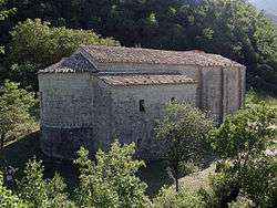 Abbey of St. Mary of Styria, on the Mount Cucco | ||
| ||
.svg.png) Scheggia e Pascelupo within the Province of Perugia | ||
 Scheggia e Pascelupo Location of Scheggia e Pascelupo in Italy | ||
| Coordinates: 43°24′N 12°40′E / 43.400°N 12.667°ECoordinates: 43°24′N 12°40′E / 43.400°N 12.667°E | ||
| Country | Italy | |
| Region | Umbria | |
| Province | Perugia (PG) | |
| Frazioni | Belvedere, Casacce, Col di Peccio, Isola Fossara, Monte Bollo, Perticano, Pascelupo, Ponte Calcara | |
| Government | ||
| • Mayor | Fabio Vergari | |
| Area | ||
| • Total | 63 km2 (24 sq mi) | |
| Elevation | 580 m (1,900 ft) | |
| Population (30 June 2016)[1] | ||
| • Total | 1,376 | |
| • Density | 22/km2 (57/sq mi) | |
| Demonym(s) | Scheggiaioli | |
| Time zone | UTC+1 (CET) | |
| • Summer (DST) | UTC+2 (CEST) | |
| Postal code | 06027 | |
| Dialing code | 075 | |
| Website | Official website | |

Scheggia e Pascelupo is a comune (municipality) in the Province of Perugia in the Italian region Umbria, located about 40 km northeast of Perugia. The municipal seat is located in the main village of Scheggia, just below Scheggia Pass on Route SS/SR 3, following the ancient Via Flaminia.
History
The site was a Roman colony on the Via Flaminia, with a temple of Jupiter of which no traces have been found however. In the Middle Ages it was a possession of Perugia and then of the Montefeltro, until it became part of the Papal States.
Pascelupo, autonomous municipality still 1878, merged into the one Scheggia forming the actual municipality.
Scheggia e Pascelupo, located close to the borders with the Marche region, borders with the following municipalities: Cantiano, Costacciaro, Frontone, Gubbio, Sassoferrato, and Serra Sant'Abbondio.
Main sights
The abbey of Sant'Emiliano in Congiuntoli is situated close to the municipality.
References
External links
![]()
- (in Italian) Scheggia e Pascelupo official website
