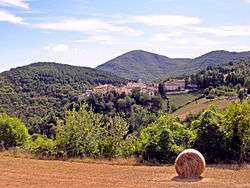
Poggiodomo
| Poggiodomo | ||
|---|---|---|
| Comune | ||
| Comune di Poggiodomo | ||
 | ||
| ||
 Poggiodomo Location of Poggiodomo in Italy | ||
| Coordinates: 42°43′N 12°56′E / 42.717°N 12.933°E | ||
| Country | Italy | |
| Region | Umbria | |
| Province | Perugia (PG) | |
| Frazioni | Mucciafora, Roccatamburo, Usigni | |
| Government | ||
| • Mayor | Egidio Spada | |
| Area | ||
| • Total | 40.09 km2 (15.48 sq mi) | |
| Elevation | 974 m (3,196 ft) | |
| Population (30 June 2017[1]) | ||
| • Total | 106 | |
| • Density | 2.6/km2 (6.8/sq mi) | |
| Demonym(s) | Pojani (Poiani) | |
| Time zone | UTC+1 (CET) | |
| • Summer (DST) | UTC+2 (CEST) | |
| Postal code | 06040 | |
| Dialing code | 0743 | |
| Patron saint | St. Anthony of Padua | |
| Saint day | Last week of August | |
| Website | Official website | |
Poggiodomo is a comune (municipality) in the Province of Perugia in the Italian region Umbria, located about 80 km southeast of Perugia.
Poggiodomo borders the following municipalities: Cascia, Cerreto di Spoleto, Monteleone di Spoleto, Sant'Anatolia di Narco, Vallo di Nera.
References
External links

This article is issued from
Wikipedia.
The text is licensed under Creative Commons - Attribution - Sharealike.
Additional terms may apply for the media files.