Preci
| Preci | ||
|---|---|---|
| Comune | ||
| Comune di Preci | ||
 | ||
| ||
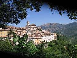
 Preci Location of Preci in Italy | ||
| Coordinates: 42°53′N 13°2′E / 42.883°N 13.033°ECoordinates: 42°53′N 13°2′E / 42.883°N 13.033°E | ||
| Country | Italy | |
| Region | Umbria | |
| Province | Perugia (PG) | |
| Frazioni | Abeto, Acquaro, Belforte, Castelvecchio, Collazzoni, Collescille, Corone, Fiano d'Abeto, Montaglioni, Montebufo, Piedivalle, Poggio di Croce, Roccanolfi, Saccovescio, San Vito, Todiano, Valle | |
| Government | ||
| • Mayor | Pietro Bellini | |
| Area | ||
| • Total | 81.7 km2 (31.5 sq mi) | |
| Elevation | 596 m (1,955 ft) | |
| Population (2007)[1] | ||
| • Total | 799 | |
| • Density | 9.8/km2 (25/sq mi) | |
| Demonym(s) | Preciani | |
| Time zone | UTC+1 (CET) | |
| • Summer (DST) | UTC+2 (CEST) | |
| Postal code | 06047 | |
| Dialing code | 0743 | |
| Patron saint | Madonna della Pietà | |
| Saint day | June 7 | |

Preci is a comune (municipality) in the Province of Perugia in the Italian region Umbria, located about 60 km southeast of Perugia.
It is a medieval burg (13th century) developed inside a fortress, which was almost entirely destroyed by an earthquake in 1328.
Preci borders the following municipalities: Castelsantangelo sul Nera, Cerreto di Spoleto, Norcia, Visso.
The old centre of Preci was badly damaged[2] in the October 2016 Central Italy Earthquakes.
As at July 2018, the old centre of Preci is entirely closed off to visitors pending reconstruction work.
Main sights
- Remains of the 13th-century castle in the frazione of Acquaro
- Pre-historic grotto tombs, in the frazione of Fiano d'Abeto
- Church of Annunziata in Poggio di Croce. It houses a 14th-century fresco of the Annunciation by Giovanni del Biondo
References
- ↑ All demographics and other statistics: Italian statistical institute Istat.
- ↑ Haworth, Jessica (2016-11-25). "Aftermath of Italy earthquake shows workers try to restore 700-year-old church". mirror. Retrieved 2018-07-21.

| Authority control |
|---|
This article is issued from
Wikipedia.
The text is licensed under Creative Commons - Attribution - Sharealike.
Additional terms may apply for the media files.