Savigny-en-Septaine
| Savigny-en-Septaine | ||
|---|---|---|
| Commune | ||
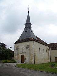 The church in Savigny-en-Septaine | ||
| ||
 Savigny-en-Septaine Location within Centre-Val de Loire region  Savigny-en-Septaine | ||
| Coordinates: 47°02′42″N 2°33′41″E / 47.045°N 2.5614°ECoordinates: 47°02′42″N 2°33′41″E / 47.045°N 2.5614°E | ||
| Country | France | |
| Region | Centre-Val de Loire | |
| Department | Cher | |
| Arrondissement | Bourges | |
| Canton | Avord | |
| Intercommunality | La Septaine | |
| Government | ||
| • Mayor (2008–2014) | Dominique Marcel | |
| Area1 | 22.58 km2 (8.72 sq mi) | |
| Population (2008)2 | 672 | |
| • Density | 30/km2 (77/sq mi) | |
| Time zone | UTC+1 (CET) | |
| • Summer (DST) | UTC+2 (CEST) | |
| INSEE/Postal code | 18247 /18390 | |
| Elevation |
137–172 m (449–564 ft) (avg. 148 m or 486 ft) | |
|
1 French Land Register data, which excludes lakes, ponds, glaciers > 1 km2 (0.386 sq mi or 247 acres) and river estuaries. 2 Population without double counting: residents of multiple communes (e.g., students and military personnel) only counted once. | ||
.svg.png)
Savigny-en-Septaine is a commune in the Cher department in the Centre-Val de Loire region of France.
Geography
A farming area comprising a village and a couple of hamlets situated about 6 miles (9.7 km) southeast of Bourges, at the junction of the D976 with the D46 and the D66 roads. The village lies on the left bank of the river Airain, which flows north through the middle of the commune, then flows into the Yèvre, which forms part of the commune's northern boundary.
Population
| Historical population | ||
|---|---|---|
| Year | Pop. | ±% |
| 1962 | 394 | — |
| 1968 | 449 | +14.0% |
| 1975 | 499 | +11.1% |
| 1982 | 546 | +9.4% |
| 1990 | 570 | +4.4% |
| 1999 | 622 | +9.1% |
| 2008 | 672 | +8.0% |
Sights
- The church of St. Etienne, dating from the thirteenth century.
- A watermill.
See also
References
External links
| Wikimedia Commons has media related to Savigny-en-Septaine. |
- Old postcard photos of the commune (in French)
- Unofficial commune website (in French)
- Savigny-en-Septaine on the Quid website (in French)
This article is issued from
Wikipedia.
The text is licensed under Creative Commons - Attribution - Sharealike.
Additional terms may apply for the media files.